Lobuche East Expedition

EARLY BIRD! Enduring Nepal

Lobuche East Expedition

NEXT DATE:

NEXT DATE:

$12,431,370
$11,436,860

A 6000 METER HIMALAYAN EXPEDITION IN THE SHADOW OF MOUNT EVEREST.

Our Lobuche East Expedition is a serious 6000 meter Himalayan climbing journey in the shadow of Mount Everest. Depending on your chosen route, the expedition approaches Lobuche East either through the remote Gokyo Lakes and Cho La Pass route or through the classic Everest Base Camp and Kala Patthar acclimatisation journey. From Kathmandu to the Khumbu, every stage is designed to prepare you for the mountain: steady acclimatisation, expert trekking support, technical climbing training, high altitude camps, and a summit attempt led by certified high altitude climbing guides. With LHO Team Leader support, specialist mountain leadership on Lobuche East, and one helicopter sector between Kathmandu and Lukla included, this is a powerful next step for trekkers ready to move into real Himalayan mountaineering.

Climbing and Mountaineering

TRIP TYPE

Climbing and Mountaineering

Trip duration

DURATION

19 Days

Trip Destination

DESTINATION

Nepal

1

An all inclusive Lobuche East Expedition with a choice of Gokyo Lakes or Everest Base Camp approach, selected tea houses, technical high altitude camps and built in weather contingency.

2

Trip photography is included throughout the experience, giving you a lasting record of the Khumbu trail, high camps, training days, summit push, and mountain moments.

3

Your expedition includes one helicopter sector between Kathmandu and Lukla, used either inbound or outbound depending on conditions, to reduce the risk of Lukla disruption.

Trip photographer to capture it all
Small groups and great community vibes only
No hidden costs its all included
Hassle free airport to airport service
Directly led by us and our local experts
Carefully curated to make it all epic

Lobuche East Expedition Dates & Prices

2026

DATE & STATUS

ROUTE

PRICE

TEAM LEADER

AVAILABILITY

Lobuche East Expedition

$12,431,370
$11,436,860

EARLY BIRD!
AVAILABLE
BOOK

2027

DATE & STATUS

ROUTE

PRICE

TEAM LEADER

AVAILABILITY

Lobuche East Expedition

$12,431,370
$11,436,860

EARLY BIRD!
6 PLACES!
BOOK

Select Your Route

Lobuche East Expedition Inclusions & Exclusions

WHAT'S INCLUDED IN THIS TRIP

  • Dedicated LHO Team Leader/Photographer
  • Carefully Selected and Certified Trekking Guides and Porters
  • 2 Nights in a Trendy, Comfortable Hotel in Kathmandu
  • Selected Tea House Accommodation on the Trail
  • Upgraded Accommodation in Namche Bazaar and Gokyo
  • Technical Tents at Lobuche Lower Camp/Higher Camp
  • All Meals Throughout the Itinerary
  • Welcome and Farewell Dinners in Kathmandu
  • Safe Drinking Water Throughout the Trip
  • Airport Transfers to and from Tribhuvan International Airport
  • All Transportation Within the Itinerary
  • Local Air Travel to and from Lukla
  • Permits and Certificates
  • Personal Duffle Bags up to 12 Kgs
  • Fitness and Nutrition Guides
  • Gear Shopping Assistance
  • LHO Base Camp (Office) Support
  • Bad Weather Contingency Days
  • Summit Bonus to the Climbing Guide (Local Tradition)

WHAT'S NOT INCLUDED IN THIS TRIP

  • International Flights and Entry Visas
  • Tips/Gratuities to the Local Team
  • Personal Gear and Rentals
  • Personal Medical/Travel Insurance/Cancellation Insurance
  • Any Extra Nights Beyond Those Listed in the Itinerary
  • Individual Departure from the Itinerary

Lobuche East Expedition Inclusions & Exclusions

WHAT'S INCLUDED IN THIS TRIP

  • Dedicated LHO Team Leader
  • Trip Photography
  • Carefully Selected and Certified Trekking Guides and Porters
  • Carefully Selected and Certified High Altitude Climbing Guides
  • 2 Nights in a Trendy, Comfortable Hotel in Kathmandu
  • Selected Tea House Accommodation on the Trail
  • Technical Tents at Lobuche Lower Camp/Higher Camp
  • All Meals Throughout the Itinerary
  • Welcome and Farewell Dinners in Kathmandu
  • Safe Drinking Water Throughout the Trip
  • Airport Transfers to and from Tribhuvan International Airport
  • All Transportation Within the Itinerary
  • Local Air Travel to and from Lukla
  • Permits and Certificates
  • Personal Duffle Bags up to 12 Kgs
  • Fitness and Nutrition Guides
  • Gear Shopping Assistance
  • LHO Base Camp (Office) Support
  • Bad Weather Contingency Days
  • Summit Bonus to the Climbing Guide (a Local Tradition)

WHAT'S NOT INCLUDED IN THIS TRIP

  • International Flights and Entry Visas
  • Tips/Gratuities to the Local Team
  • Personal Gear and Rentals
  • Personal Medical/Travel Insurance/Cancellation Insurance
  • Any Extra Nights Beyond Those Listed in the Itinerary
  • Individual Departure from the Itinerary

Lobuche East Expedition Itinerary

DAY 1: WELCOME TO WILD KATHMANDU

Kathmandu is an incredible, vibrant, and wild city that we’ve fallen in love with. That’s why we’re always so excited to receive you on the first day and share the gateway to the Himalayas with you.

On arrival day, you’ll be met by an LHO representative at the airport and driven to our centrally located hotel by private transfer. Navigating Kathmandu airport can be an adventure in and of itself, so you’ll receive a text with detailed instructions on how to efficiently make your way to us.

Your LHO Team Leader will be waiting to receive you at our hotel, check you in, and make sure that you have everything you need for our adventure. If you arrive early, there are loads of incredible places to visit around us. Your LHO Team Leader will send you a detailed list of restaurants, coffee shops, heritage sites, and markets to visit closer to your trip start date so that you can make the most of your time.

Our first official event of the trip is a team dinner at 7:30 pm hosted by your LHO Team Leader and local lead guide. This will be your first opportunity to meet everyone, ask any questions you have, hear all about the amazing week ahead of us, and enjoy a great meal. Although it’s difficult not to be tempted by the nearby nightlife, we recommend an early rest to recover from your travels.

DAY 2: EXPLORING THE GATEWAY TO THE HIMALAYAS

Our first full day together gives us an opportunity to discover the magical city of Kathmandu, check our gear, and get to know each other before we head out to the trail. We’ll visit the nearby sites of Durbar Square and the Monkey Temple as well as get our first taste of Nepali cuisine during our team lunch.

Due to air traffic in Kathmandu airport, the government sometimes takes the decision to assign all flights to the Everest region from an alternative airport three hours away from the city. We’ve determined that waking up exceptionally early on the day of the flight to make the land journey limits the much-needed rest before heading out on our adventure. That’s why, if flights won’t be departing from Kathmandu Airport, we will make our way to a hotel closer to our departure airport today. This gives us a chance to have a full night’s rest.

Your Team Leader will inform you about the plans of the day upon your arrival in Kathmandu as this information can change regularly. Regardless, our team dinner will be at the accommodation we sleep at on the night.

DAY 3: TASHI DELEK

Distance: 8.7 KM | Ascent: 364 M | Descent: 521 M | Max Altitude: 2,860 M


Our day starts after breakfast as we make our way to the airport to board one of the most incredible flights you’ll ever take. As with all internal flights, delays are expected. Flights to Lukla are particularly notorious for never departing on time. Not to worry, though, every moment spent waiting is worth it when we get there. The flight itself takes about fifty minutes.

Once in Lukla, we’ll be met by our porter team who will collect our duffle bags and take them to a local tea house where we’ll have lunch and prepare ourselves for the trek to Phakding. Lukla is one of the most vibrant villages in the Khumbu region. It’s an important hub of local and regional commerce as well as the border to the sacred high-altitude regions. Above Lukla, animal slaughter is religiously banned. That’s why we don’t recommend choosing any meat or chicken options above Lukla.

The trail begins at the entrance of the village and is actually mostly descending in the alpine forests and through the many towns that dot this section of the trail. The Tibetan influence and Buddhist character of the area are immediately apparent in the calligraphy, architecture, and religious stupas and shrines.

Our accommodation sits just above Phakding near the Khumbu river that is formed from the melting glaciers of the towering summits of the region, including Everest. Depending on our arrival time, it may be possible to explore the coffee shops and market streets of the village before dinner.

DAY 4: NAMCHE BAZAAR

Distance: 9.1 KM | Ascent: 1,095 M | Descent: 380 M | Max Altitude: 3,440 M


Our second day on the trail will be a full-on ascent to an impressive altitude of 3,445 meters, arriving at one of the most vibrant and remote high-altitude towns on the planet: Namche Bazaar. The trail begins by following the river and passes through the alpine forests. The trail is once again dotted by a series of villages and farming communities that add an incredible element of rural life to the walk.

Our first main objective is reaching the town of Monjo. This is the official entrance to the Sagarmatha National Park. There is a brief checkpoint where we present your permits to the authorities. Once through, we’ll descend a series of staircases flanked by Tibetan calligraphy carved into the rocks. We’ll stop for lunch at the last village in the valley before the direct ascent to Namche Bazaar. The trail to Namche is predominantly ascending and sustained. Your LHO Team Leader will help set the pace so that we can efficiently overcome the challenge without wasting energy unnecessarily.

Slow and steady is the name of the game here as we make our way up a series of stairs, cross the epic Tenzing-Hillary suspension bridge, and join the winding trail through the pine forest that leads to the village entrance. There’s a viewpoint of Everest halfway up to the top. On a clear day, this offers the first opportunity to see the world’s highest summit, albeit from afar. We’ll also use this as an opportunity to take a break and use the serviced bathrooms available there.

The reward at the end of our ascent is our arrival in the incredible Sherpa town of Namche, nestled between the towering summits of the high Himalayas. After checking into our tea house, we’ll have plenty of opportunities to explore the markets, coffee shops, and bars that give this place so much life. This will be our home for the next two nights. Dinner will be at our tea house.

DAY 5: FIRST SIGHT OF EVEREST

Distance: 5.5 KM | Ascent: 503 M | Descent: 503 M | Max Altitude: 3,700 M


We’ll be staying in Namche Bazaar for a second night. That means we don’t have to repack our bags or check out from the Tea House. Our day will slowly start after breakfast. We’ll climb to the top of the town and visit the Sherpa museum where we can learn about the Sherpa culture, mountaineering history of the region, and about new sustainability practices that your visit to the region helps finance.

From there, we’ll trek to the hilltop high above the village to acclimatize by exposing ourselves to higher altitudes. The hilltop offers a jaw-dropping view of Everest, Lhotse, and Ama Dablam, three of the most iconic summits on the planet. We’ll be able to see all the way up the Khumbu valley and get a visual representation of what lies ahead of us.

DAY 6: ENTERING THE GOYKO VALLEY

Distance: 10 KM | Ascent: 895 M | Descent: 592 M | Max Altitude: 3,965 M


Our journey begins with an ascent from Namche to the Syangboche airstrip, a site that offers sweeping views of the surrounding valleys and peaks. The summits visible include Kande, Thamserku, Ama Dablam, Lhotse, and eventually Mount Everest as well!

As we continue, the trail leads us to Khumjung, the largest village in the Khumbu region, known for its traditional Sherpa houses and the famous Khumjung Monastery. Walking through the village, you’ll feel the rich cultural heritage that pervades this high-altitude settlement. Leaving Khumjung behind also means leaving the crowds of trekkers and climbers that dot the traditional Everest Base Camp route. From here, our trail becomes far less crowded and far more remote.

The trail then contours around the lower slopes of Khumbila, a sacred mountain for the Sherpas, passing through serene birch forests where the air is crisp and filled with the scent of the wilderness. Reaching a stupa on a rocky ridge at 3,992 meters, we pause to take in the breathtaking panoramic views. This is the gateway to the Gokyo Valley, at the end of which is the impressive south face of Cho Oyu, the world’s 6th highest mountain.

We usually pause for lunch here before beginning our descent into the tranquil woodlands surrounding Phortse Tenga, nestled quietly by the river. This is our home for the evening, and what an incredible home it is. The sound of the river against the view of the rhododendron forest makes it one of the most tranquil spots to sleep anywhere in the Khumbu region.

DAY 7: YAK FIELDS & SUMMIT VISTAS

Distance: 3.5 KM | Ascent: 480 M | Descent: 0 M | Max Altitude: 4,050 M


To ensure proper acclimatisation, our journey to Gokyo is paced over three days. After breakfast, we’ll depart Phortse Tenga and embark on a sustained and steep ascent through the forest that quickly begins to thin as we gain altitude. It won’t take long before the incredible landscape opens up to reveal spectacular vistas of towering peaks such as Kantega, Thamserku, and the majestic Ama Dablam. With modest pacing and well-timed breaks, the ascent can be quite manageable and made easier by the incredibly rewarding environment that we find ourselves in. The trail contours high above the valley, providing a bird’s-eye view of the lush, green pastures and deep ravines below. The sacred mountain of Tabuche dominates the opposite bank of the valley to our right, and its beautiful ridge line connecting to Cholaste summit moves alongside us a few thousand meters into the sky.

Before long, the trail passes through the yak herding settlements of Tongba and Gyele, where the presence of these hardy animals adds a rustic charm to the journey. This is usually our lunch spot, although which of the two we stop in depends entirely on the pace of the team and the weather conditions of the day. As we approach Dole, the landscape transforms into an alpine wonderland with rolling meadows and distant snow-capped mountains creating a picture-perfect backdrop. Here, the tea houses are much more spread out and all boast incredible views. Sunsets in the Gokyo Valley are second to none and, weather permitting, this is our first opportunity to experience it.

DAY 8: TREK TO MACHHERMO

Distance: 5.2 KM | Ascent: 441 M | Descent: 80 M | Max Altitude: 4,427 M


Our day begins with a steep climb, the trail winding upward alongside the valley high above the river. The path is rugged, traversing sandy spurs and rocky outcrops that both challenge and inspire. As we progress, the views become increasingly dramatic, with Machhermo Peak and Kaju Ri along the left side of the valley and Cholatse dominating the right side among the dozens of other jagged peaks rising majestically around us.

After the initial climb, the trail follows what the locals call “Nepali Flat.” This implies hilly terrain that ascends and descends haphazardly without any overall change in altitude. We’ll follow the Nepali Flat until we reach Machhermo, a picturesque village set against a stunning backdrop of towering mountains. At the end of the Machhermo Valley is Machhermo Peak, towering high above the village. The serenity of this place, coupled with the sweeping panoramic vistas, makes this yet another unique place to rest, recover, and spend some time alone with the highest mountains on the planet. The village itself is a charming collection of stone houses and tea lodges. There are usually a few wild yaks around as well!

We usually arrive relatively early on this day, giving us time to allow our bodies to recover and acclimatise for the high-altitude environment that lies ahead. Dinner will be hosted at our tea house in the village.

DAY 9: GOKYO!!

Distance: 7.3 KM | Ascent: 442 M | Descent: 67 M | Max Altitude: 4,756 M


Today’s trek takes us along a ridge, where the valley begins to widen, offering expansive views that stretch for miles. After breakfast, we head out in a northbound direction, where the trail leads us to Pangka, a peaceful spot where the beauty of the landscape is accentuated by the clear, crisp air. Here, the tranquility of the surroundings provides a perfect moment to pause and soak in the serene atmosphere. At a fork in the trail, we choose the path to Gokyo on the left, while the right path leads to the Cholaste base camp across the river.

After a brief descent, we climb to a large cave area known as Nilibuk, a place steeped in ancient myths and natural wonder. The cave, with its intriguing formations and historical significance, invites a sense of curiosity and exploration.

Continuing on, we arrive at the first of Gokyo’s five enchanting turquoise lakes, each one more mesmerizing than the last, set against the towering backdrop of snow-capped peaks, the highest of which is Cho Oyu. The pristine waters of these glacial lakes reflect the stunning panorama, creating a breathtaking and otherworldly scene. The landscape here is truly a testament to the raw beauty of the high Himalayas, with its rugged terrain, vibrant hues, and majestic peaks that seem to touch the sky.

As we make our way through this ethereal environment, the awe-inspiring vistas and serene surroundings remind us of the remarkable journey we are on and the incredible natural wonders that await us at every turn. Our evening is spent in the lakeside town of Gokyo. There are few words that can truly capture just how magnificent this place is.

DAY 10: GOKYO RI - THE BEST VIEW IN THE HIMALAYAS

Distance: 3.3 KM | Ascent: 590 M | Descent: 590 M | Max Altitude: 5,360 M


Before dawn, we begin our hike to Gokyo Ri (5,357m), a challenging ascent that rewards us with one of the most breathtaking panoramic views in the Himalayas. The trek is moderately inclined, but at these altitudes, even gradual ascents can feel very challenging. Although climbing Gokyo Ri is optional, we highly recommend it.

As the trail ascends, the width of the mountain begins to shrink, culminating in a pinnacle at the top, which typically takes around three hours to reach. Once there, the views are jaw-dropping. Everest, Lhotse, Cho Oyu, and Makalu are just a few of the famous summits that open up in front of us. We can even see the famous South Col of Mount Everest, where climbers pitch Camp Four before making their ascent to the summit.

As the sun rises, the peaks of Everest, Lhotse, Makalu, and Cho Oyu are bathed in a golden glow, a sight that leaves a lasting impression. Once we’ve enjoyed ourselves and taken loads of pictures, we’ll make our way back down to the tea house. The rest of the day is free for you to rest, relax, or take an optional exploratory walk around the Gokyo region, a landscape filled with natural wonders and tranquil beauty. We recommend recovering as much as possible because the next day, trekking over the pass into the Khumbu Valley, is the most objectively challenging day of the trip.

DAY 11: GOKYO TO DRAGNAG

Distance: 7 KM | Ascent: 180 M | Descent: 335 M | Max Altitude: 4,800 M

After breakfast beside the turquoise waters of Gokyo Lake, we begin our journey toward Dragnag. The trail starts gently along the lakeshore before climbing onto the rugged moraine of the immense Ngozumpa Glacier. As we ascend, sweeping views unfold of Cho Oyu dominates the skyline, while the glacier’s vast, rippling surface stretches out below.

Crossing Ngozumpa Glacier is a deliberate and careful process. The terrain constantly shifts between loose rock, scree, and undulating ice formations shaped over centuries. Progress is slow but steady as we navigate the ridges and troughs of this dramatic, otherworldly landscape.

Upon reaching the far side, the trail reconnects with firmer ground and follows a gently rising traverse toward Dragnag. The final approach is easier underfoot, and before long, the small, secluded cluster of lodges comes into view. Tucked beneath the imposing ridge that leads to Cho La Pass, Dragnag is our quiet base for the night, offering a chance to rest and prepare for one of the most demanding days of the trek.

DAY 12: DRAGNAG TO LOBUCHE VIA CHO LA PASS (5,420m)

Distance: 13 KM | Ascent: 770 M | Descent: 620 M | Max Altitude: 5,420 M

We start before dawn for one of the trek’s toughest days. The trail climbs steadily toward the base of Cho La Pass, growing steeper as the morning light reveals the rocky slopes ahead.

The ascent to the pass is demanding, with a short glacier crossing near the top that may require extra care. Reaching Cho La (5,420m) is a proud moment, rewarded with striking views of surrounding peaks and ridgelines.

The descent begins steeply before easing into a long, gradual walk through glacial terrain. Eventually the trail joins the main Everest route, leading us to Lobuche, where we rest and prepare for the climb the following day.

DAY 12: THE ASCENT OF LOBUCHE BEGINS – 5400 m

Distance: 2.8 KM | Ascent: 359 M | Descent: 63 M | Max Altitude: 5,400 M


After an early breakfast, we’ll begin our ascent to Lower Camp, also known as Advanced Base Camp. The trail to the camp is not technical and requires only mild scrambling skills, similar to what we would have experienced when approaching Everest Base Camp or Kalapathar summit. The trail begins gradually in a southerly direction. We will be able to see the valley we trekked when we hiked to Lobuche from Dingboche a few days earlier. The trail follows the circular cone of the mountain until we reach a series of large rocky structures. Here is where we’ll employ some basic scrambling skills before reaching the plateau above. From there, it’s a short walk to our camp situated next to an incredible glacier lake. The views of the lower Khumbu and Gokyo summits are nothing short of breathtaking. The giants on the Everest side will now be hidden from view by the towering Lobuche East summit above us. The next time we’ll see the roof of the world is from the roof of Lobuche! After checking in and getting the full briefing from your local lead guide and LHO Team Leader, we’ll continue with our training. We’ll once again limit our time to a couple of hours so as not to tire ourselves too extensively. Dinner will be early at the campsite so that we can get a good night’s rest.

DAY 13: LOBUCHE HIGHER CAMP – 5700 m

Distance: 1.2 KM | Ascent: 434 M | Descent: 8 M | Max Altitude: 5,700 M


In some instances, we may choose to climb directly to the summit of Lobuche from lower camp. This may be necessary during seasons when higher camp is either unsafe, not properly equipped, or due to weather considerations. If we choose to climb directly to the summit, we will get an early start with the aim of returning to high camp for one more night. If we follow our regular schedule, then we’ll depart for higher camp after breakfast. The trek begins by circling around to the opposite bank of the glacier lake before ascending a series of rock slabs of varying inclines. Usually, these slopes are not covered in snow and do not require the use of technical gear. We will, however, be wearing our harnesses and helmets because we may require the use of a rope if we encounter any unexpected ice. There are a couple of fixed ropes on the steeper slabs. Higher Camp sits at the very start of the glacier. The slabs lead straight to the camp with some intervening flat parts that are similar to the trails we’ve been used to from earlier in the week. Once we arrive at Higher Camp, we will follow the same procedures that we would have been accustomed to. Check-in comes first. Depending on our arrival time, we may have lunch directly or rest first. The afternoon will consist of training on the use of crampons and ice axes, as well as a review of how to safely use the fixed rope system that we follow all the way to the summit. Dinner will be early at the High Camp so that we can get a full night’s rest.

DAY 14: SUMMIT! SUMMIT! SUMMIT! – 6119 m

Distance: 2.2 KM | Ascent: 587 M | Descent: 1,953 M | Max Altitude: 6,119 M


If we’ve followed Plan B, then this day will be dedicated to descending from High Camp to Pheriche and potentially lower. Following our Plan A, we’ll depart from High Camp just before daybreak. The ascent from High Camp to the summit should take between 3 to 4 hours depending on our pace. We’ll head north from the camp directly beneath the summit where the start of the first fixed rope is located. The exit from the camp towards the summit is the most technically demanding section because of the ice on the rocks. Luckily, we would have had the opportunity to train on exactly that spot on the previous day. We’ll exit the rocky couloir onto a snow slab with clear steps usually dug into the snow and ice by previous climbers. The fixed ropes are easy to follow and guide our way. However, it is important not to rely on them to pull yourself up. You should rely on the training that focuses on using your feet and your balance. It is much more efficient, conserves energy, and is safer. The fixed ropes are there to assist. They are not there to climb for you. The training continues with four consecutive fixed ropes, each of about one hundred meters in length. At the top of the last fixed rope in this series is a plateau of snow and ice just a few meters beneath the summit. The narrow summit ridge and marginally steep section to mount the ridge create a bit of a bottleneck. During big seasons, we may need to wait for other climbers on the plateau before we are able to safely access the summit without obstruction. It takes less than 10 minutes to reach the summit from the plateau. Once on the ridge, the entire Everest range comes into view once again. In fact, from the summit, it is possible to see the 8000 meter summits of Shishapingma, Choy Oyu, Everest, Lhotse, and Makalu. It’s an incredible experience. We will try to spend as much time as we can on the summit to take pictures and appreciate our achievement. Weather and the traffic of other climbers may limit the time we can spend. Either way, we still have a big descent ahead of us, and it’s best to get started as soon as possible. The descent is similar to the ascent in that we’ll follow the fixed ropes all the way back to Higher Camp. We may need to abseil to access the plateau at the start of the descent. Special attention needs to be given to the last section of icy rock. In some instances, abseiling may be desirable there as well. Your guide and LHO Team Leader will always be at an arm’s length to advise you and ensure we are all practicing the safest possible techniques in every situation. Once at the camp, we’ll have a second breakfast, pack up our tents, and start our descent along the rock slabs back to Lower Camp. We are normally able to reach Lower Camp in a relatively speedy fashion since our energy is regained from the higher oxygen absorption at lower altitudes. Depending on what time we arrive, we may either have a snack or lunch before continuing down to the town of Pheriche. Lunch will be at the Tea Houses of Thukla. After some rest, we’ll begin a descending portion of the trail that differs from what we used on the way up. The descent is quite steep as we drop altitude rapidly and find ourselves on a flat, easy walk near the north faces of Cholatse and Tabouche. Ama Dablam will once again come into view straight ahead of us, and Lobuche summit will now be clearly visible directly behind us. At the end of the valley is the town of Pheriche, our home for the evening. Pheriche is a hub for helicopter traffic because it has a high-altitude clinic that provides medical support to nearby climbing expeditions. There are a few coffee shops to visit as life slowly starts to return to the villages of the lower altitude environment. Dinner will be at our Tea House.

DAY 15: THE TREES GROW AGAIN

Distance: 10.5 KM | Ascent: 323 M | Descent: 766 M | Max Altitude: 4,371 M


For those of us who have chosen to take a helicopter back to Lukla and onwards to Kathmandu, this is where we’ll bid our farewells. You will be escorted by a member of the LHO team to Lukla and then be taken to Lukla airport for your flight. Once you land in Kathmandu, a member of the LHO Team will collect you and shuttle you to the hotel. For the rest of us, after breakfast, we’ll reconnect with the trail that follows the Khumbu River in the direction of Ama Dablam. As the valley starts to get steeper, the trail will veer to the right and follow an embankment that reconnects with the ascending trail that goes up to Dingboche. We’ll continue along the descending route until we reach the familiar town of Pangboche, where we’ll stop for lunch and take our time to enjoy the views of the border regions between the lush lower valley and the dazzling white peaks of the upper regions. We’ll resume the descent along the stairs that lead to the suspension bridge on the edge of the Rhododendron forest. The challenging portion of the trail is actually the final ascent in the forest to the pass, where the Tyangboche monastery sits. Depending on the pace of the team, it may be possible to descend beyond the monastery to Tea Houses closer to Namche Bazaar. Your LHO Team Leader and guide will make an assessment closer to the time and brief you on the final destination.

DAY 16: THE HUSTLE AND BUSTLE OF VILLAGE LIFE RETURNS

Distance: 14.5 KM | Ascent: 688 M | Descent: 1,685 M | Max Altitude: 3,860 M


Tyangboche is the last truly remote village along the trail, and nothing represents this more acutely than departing from the monastery and passing through Namche Bazaar. Both are charming and beautiful in their own rights, but they couldn’t be more different. The trail starts with a long descent to the valley floor before crossing a series of suspension bridges and ascending the pine forest to the junction between the Khumbu and Gokyo valleys. In the forest, we’ll stop at a tea house for a break before continuing to the high point of the day. This is the final big ascent of the entire experience. As we approach Namche, we’ll start to see small market stalls along the trail and the familiar sight of donkey caravans that are replaced by yaks in the higher altitudes. From there, it’s a short walk to Namche, where we’ll stop for lunch. Depending on our pace, it may be possible to roam around before we continue our descent through the forest, across the Tenzing-Hillary suspension bridge, and finally to the valley floor where the town of Monjo awaits. Our night will be spent at a Tea House in the town.

DAY 17: THE GATEWAY TO REALITY

Distance: 12.6 KM | Ascent: 722 M | Descent: 715 M | Max Altitude: 2,835 M


The end of the trail is the Sherpa village of Lukla, home to the Tenzing-Hillary airport. Monjo is within a few hours of Lukla. This gives us the option of catching a flight out on this day instead of the next, should we find that weather may obstruct flights on the following day. Assuming that the conditions are favorable, we’ll start slowly after breakfast and take our time to visit and enjoy the many villages that are along this section of the trail. Yes, we did pass through them on the way up, but the mindset was different. It’s so much more enjoyable to have this experience once the objective of the adventure is behind us. Lunch will be in Phakding along the trail, and we’ll have plenty of opportunities to stop for tea and coffee. The final push to Lukla is a mild challenge as we ascend a series of stairs and village trails to the entrance of the town. The afternoon is free to explore the coffee shops, pubs, markets, and stores. We’ll spend our last night on the trail at a local Tea House, where we’ll also share our last trail dinner.

DAY 18: KATHMANDU DOESN'T CHANGE

Hot showers await us on our return to Kathmandu! We’ll be catching our flight out early in the morning; however, this depends entirely on the weather situation. Patience is key when it comes to aviation in Nepal, although we’ll do our best to make it as smooth as possible. Depending on when we move, lunch will either be in Lukla, Kathmandu, or the alternative airport sometimes used to direct Lukla air traffic that is inbound to Kathmandu. Wherever we finally land, we’ll do our best to get you to the hotel as soon as possible so that you can shower, rest, and enjoy Kathmandu before our farewell dinner.

DAY 19: NAMASTE!

The last day together is dedicated to airport transfer and farewells. Breakfast is included on the day. Please make sure to provide us with the correct departure details when filling out your Team Details Form before the first day of the trip so that arrangements can be made. We’ll be arranging your shuttle 3 hours before departure, so please make sure to be near the hotel at the time so as not to be late. For those of us departing late, we’re happy to recommend places to visit or arrange for a city tour if you weren’t able to attend it on the first day. Please communicate any changes to your flight with your LHO Team Leader as soon as possible so that arrangements can be made.


CAN’T TAKE THIS MANY DAYS OFF?


It is possible to shorten this trip to 16 days by taking a helicopter back down from Gorakshep. Ask us about the shorter itinerary by reaching out to us at info@lifehappensoutdoors.com.


DAY 1: ARRIVAL IN KATHMANDU AND ISLAND PEAK EXPEDITION WELCOME BRIEFING

Kathmandu is an incredible, vibrant, and wild city that we’ve fallen in love with. That’s why we’re always so excited to receive you on the first day and share the gateway to the Himalayas with you.

On arrival day, you’ll be met by an LHO representative at the airport and driven to our centrally located hotel by private transfer. Navigating Kathmandu airport can be an adventure in and of itself, so you’ll receive a text with detailed instructions on how to efficiently make your way to us.

Your LHO Team Leader will be waiting to receive you at our hotel, check you in, and make sure that you have everything you need for our adventure. If you arrive early, there are loads of incredible places to visit around us. Your LHO Team Leader will send you a detailed list of restaurants, coffee shops, heritage sites, and markets to visit closer to your trip start date so that you can make the most of your time.

Our first official event of the trip is a team dinner at 7:30 pm hosted by your LHO Team Leader and local lead guide. This will be your first opportunity to meet everyone, ask any questions you have, hear all about the amazing week ahead of us, and enjoy a great meal. Although it’s difficult not to be tempted by the nearby nightlife, we recommend an early rest to recover from your travels.

DAY 2: KATHMANDU CITY TOUR, GEAR CHECK AND LUKLA FLIGHT PREPARATION

Our first full day together gives us an opportunity to discover the magical city of Kathmandu, check our gear, and get to know each other before we head out to the trail. We’ll visit the nearby sites of Durbar Square and the Monkey Temple as well as get our first taste of Nepali cuisine during our team lunch.

Because aviation into the Everest region is highly weather dependent, the exact Lukla travel plan is confirmed close to departure. Your itinerary includes one helicopter sector between Kathmandu and Lukla and one fixed wing domestic flight sector between Kathmandu and Lukla. The helicopter may be used on the way into Lukla or on the way back from Lukla, depending on weather, airport operations, and the plan that gives the group the smoothest overall journey. Your LHO Team Leader will confirm the plan in Kathmandu and make sure everyone is clear before we leave for the mountains. Regardless, our team dinner will be at the accommodation we sleep at on the night.

DAY 3: TRAVEL TO LUKLA AND TREK TO PHAKDING

Distance: 8.7 KM | Ascent: 364 M | Descent: 521 M | Max Altitude: 2,860 M


Our day starts early as we make our way to the airport for the journey into Lukla, the gateway to the Everest region. Depending on conditions, this sector may be operated by helicopter or fixed wing flight. Your trip includes one helicopter sector between Kathmandu and Lukla, used either inbound or outbound, and one fixed wing domestic flight sector for the other direction. This gives us more flexibility around one of the most delay prone parts of the Everest Base Camp experience while keeping the trip sensibly priced.

Once in Lukla, we’ll be met by our porter team who will collect our duffle bags and take them to a local tea house where we’ll have lunch and prepare ourselves for the trek to Phakding. Lukla is one of the most vibrant villages in the Khumbu region. It’s an important hub of local and regional commerce as well as the border to the sacred high-altitude regions. Above Lukla, animal slaughter is religiously banned. That’s why we don’t recommend choosing any meat or chicken options above Lukla.

The trail begins at the entrance of the village and is actually mostly descending in the alpine forests and through the many towns that dot this section of the trail. The Tibetan influence and Buddhist character of the area are immediately apparent in the calligraphy, architecture, and religious stupas and shrines.

Our accommodation sits just above Phakding near the Khumbu river that is formed from the melting glaciers of the towering summits of the region, including Everest. In Phakding, we use one of the better available tea houses in the village, giving you a more comfortable first night on the trail while still keeping you fully connected to the atmosphere of the Khumbu.

Depending on our arrival time, it may be possible to explore the coffee shops and market streets of the village before dinner.

Our accommodation sits just above Phakding near the Khumbu River that is formed from the melting glaciers of the towering summits of the region, including Everest. Depending on our arrival time, it may be possible to explore the coffee shops and market streets of the village before dinner.

DAY 4: TREK FROM PHAKDING TO NAMCHE BAZAAR

Distance: 9.1 KM | Ascent: 1,095 M | Descent: 380 M | Max Altitude: 3,440 M


Our second day on the trail will be a full-on ascent to an impressive altitude of 3,445 meters, arriving at one of the most vibrant and remote high-altitude towns on the planet: Namche Bazaar. The trail begins by following the river and passes through the alpine forests. The trail is once again dotted by a series of villages and farming communities that add an incredible element of rural life to the walk.

Our first main objective is reaching the town of Monjo. This is the official entrance to the Sagarmatha National Park. There is a brief checkpoint where we present your permits to the authorities. Once through, we’ll descend a series of staircases flanked by Tibetan calligraphy carved into the rocks. We’ll stop for lunch at the last village in the valley before the direct ascent to Namche Bazaar. The trail to Namche is predominantly ascending and sustained. Our trekking team will set a slow, steady pace so we can manage the ascent to Namche efficiently without wasting energy unnecessarily.

Slow and steady is the name of the game here as we make our way up a series of stairs, cross the epic Tenzing-Hillary suspension bridge, and join the winding trail through the pine forest that leads to the village entrance. There’s a viewpoint of Everest halfway up to the top. On a clear day, this offers the first opportunity to see the world’s highest summit, albeit from afar. We’ll also use this as an opportunity to take a break and use the serviced bathrooms available there.

The reward at the end of our ascent is our arrival in the incredible Sherpa town of Namche, nestled between the towering summits of the high Himalayas. After checking into our tea house, we’ll have plenty of opportunities to explore the markets, coffee shops, and bars that give this place so much life. In Namche, we use one of the stronger available tea house options in the village, giving the group a more comfortable base for rest, acclimatization, and recovery before we move higher into the Khumbu.

This will be our home for the next two nights. Dinner will be at our tea house.

DAY 5: NAMCHE BAZAAR ACCLIMATISATION AND FIRST EVEREST VIEWS

Distance: 5.5 KM | Ascent: 503 M | Descent: 503 M | Max Altitude: 3,700 M


We’ll be staying in Namche Bazaar for a second night. That means we don’t have to repack our bags or check out from the Tea House. Our day will slowly start after breakfast. We’ll climb to the top of the town and visit the Sherpa museum where we can learn about the Sherpa culture, mountaineering history of the region, and about new sustainability practices that your visit to the region helps finance.

From there, we’ll trek to the hilltop high above the village to acclimatize by exposing ourselves to higher altitudes. The hilltop offers a jaw-dropping view of Everest, Lhotse, and Ama Dablam, three of the most iconic summits on the planet. We’ll be able to see all the way up the Khumbu valley and get a visual representation of what lies ahead of us.

There’s an opportunity for a short tea break at the Everest View Hotel nearby before we descend back to Namche for lunch at our Tea House and a free afternoon to enjoy the town. Dinner will also be at our Tea House.

This second night in Namche is also one of the places where our accommodation selection matters most, giving you a better chance to rest, recover, and enjoy the village before the trail becomes more remote.

DAY 6: TREK FROM NAMCHE BAZAAR TO TENGBOCHE MONASTERY

Distance: 9.4 KM | Ascent: 901 M | Descent: 454 M | Max Altitude: 3,860 M


If you’ve ever watched a movie or documentary about climbing Everest, then you’ve surely seen scenes from the Tyanboche monastery. This is where climbers come to receive a blessing of protection before ascending the giants of the region. The monastery is exactly where we’re heading.

After breakfast, we’ll depart in the direction of the Sherpa museum, but this time we’ll continue past it and follow the wide trail that heads straight down the valley. The trek is characterized by incredible photo opportunities, stupas, and the unlimited views of towering summits all around and the fewer villages that inhabit these parts. Although the trail does begin above the tree line, we will eventually start descending toward the valley floor, re-entering the thick forest and reaching the riverside once again.

We usually stop for tea along the descending portion of the trail and have a lunch break at the riverside. After lunch and a bit of rest, we begin the long ascent to Tengboche at a manageable pace set by our trekking team, helping the group arrive feeling strong. At 3:30 pm, the monastery opens for visitors, and we’ll have a chance to visit and participate in the rituals of one of Buddhism’s holy sites before dinner and rest at our Tea House.

DAY 7: TREK FROM TENGBOCHE TO DINGBOCHE ABOVE 4000 METERS

Distance: 10.6 KM | Ascent: 773 M | Descent: 279 M | Max Altitude: 4,410 M


The 4000-meter mark is universally considered the start of the high-altitude environment. Today is the day we’ll breach that ceiling and reach 4,400 meters. After breakfast, we’ll descend into a Rhododendron forest. The Rhododendron is the national flower of Nepal, and this forest has an incredible energy that really feels like a border between worlds.

We’ll emerge from the forest onto an iconic suspension bridge, which is where it’s possible to take a photo of trekkers walking above the mountain of Ama Dablam. Once we cross the bridge, we’ll start climbing a series of staircases with the summit of Ama Dablam immediately to our right.

The trail eventually enters the remote town of Pengboche, our lunch stop for the day. After a good meal and some rest, we’ll continue along the trail as it turns behind Ama Dablam and closer to the south face of Lhotse, the world’s fourth-highest summit. The forests are now replaced with limited short grass vegetation as the drier climate becomes more apparent.

Our final destination for the day is Dingboche, our home for the next two nights. Dingboche was once primarily herding grounds for yaks. The town has developed substantially over the past decades due to its position at the crossroads of the main climbing and trekking routes in the region. Dinner will be at our Tea House.

DAY 8: DINGBOCHE ACCLIMATISATION DAY

Distance: 3.1 KM | Ascent: 476 M | Descent 476 M | Max altitude: 4,600 M


We’ll be staying in Dingboche for two nights to rest and acclimatize. The Tea Houses in this area are relatively comfortable, giving us the opportunity to relax before pushing into the higher altitude environment.

Depending on the conditions and the spirits of the group, we may choose to take a short walk up to the pass to enjoy the views and acclimatize. This is completely optional, and it’s perfectly fine to choose not to exert yourself at all on this day. There are a few coffee shops worth visiting in the town, and we’ll also have plenty of free time to do that. Both lunch and dinner will be at our Tea House.

DAY 9: TREK FROM DINGBOCHE TO LOBUCHE VIA THE THUKLA PASS

Distance: 8.2 KM | Ascent: 951 M | Descent: 91 M | Max Altitude: 4,940 M


We’ll get an early start from Dingboche, departing after breakfast in the westerly direction. The close proximity of the mountains and glaciers is immediately apparent when we exit the town. On our left are the towering summits of the Cholatse and Taboche mountain ranges. Ahead of us is Lobuche. Behind us is Ama Dablam, and to our right is the south side of Lhotse and Nuptse. This area is full of wild yaks grazing in the open spaces.

The first portion of the trail is Nepali flat, which means it’s inclined but interrupted regularly by brief flat sections and even small descents. We’ll follow the trail until we reach a river crossing that can sometimes be a little tricky to navigate because of the regularly changing trails. Our trekking team will brief the group on staying together, particularly around the river crossing, where trail conditions can change regularly.

Once we cross the river, we’ll find a small cluster of Tea Houses known as Thukla. This will be the location of our lunch break for the day. After lunch, we’ll begin the ascent to the Thukla pass. Many people will describe this as the most challenging section of the trail. With a slow, sustained, and adaptive pace set by our trekking team, the climb to the Thukla Pass becomes much more manageable than many people expect.

The top of the trail is the infamous Thukla pass, home to the dedications to the many climbers who have died in the surrounding mountains, including Everest. This is a holy place for many, and although we can certainly take pictures, we should also be respectful to those of us who come here to mourn loved ones. After a break, we’ll follow the glacier moraine in the direction of Lobuche. It’s possible to see Pumori for the first time, an impressive 7000-meter mountain that stands freely in the shadow of nearby Everest. The Lobuche Tea Houses will gradually emerge from behind the northeast slopes of Lobuche summit, and we’ll make our way directly to our accommodation. Unlike previous villages, there are no more coffee shops or market streets. We are now in the wild outback of the Nepali Himalayas. Dingboche is the last village on this trail.

DAY 10: TREK TO EVEREST BASE CAMP AND OPTIONAL KALA PATTHAR

Distance: 13.3 KM | Ascent: 997 M | Descent: 312 M | Max Altitude: 5,364 M


Unlike traditional trekking groups, we choose to depart very early for our hike to Everest Base Camp. The reason for this is that we would like to give ourselves the opportunity to optionally climb Kala Patthar on the same day to catch the sunset on Everest. It is the sunset rather than the sunrise that is exceptionally beautiful from the top because we will be observing the mountain from its west face, which means the colors are most spectacular at sunset. The trail from Lobuche starts flat and is quite similar to the final stretches of our previous day. All that changes when we begin ascending the glacier moraine. The trail shifts dramatically from flat to incredibly hilly as we go up and down the terrain dug up by the glaciers. The trail even goes onto the glacier itself, albeit a section of the glacier almost fully covered by small stones. Once the trail starts to level out, it means we’re arriving at Gorak Shep, the final collection of tea houses before Everest Base Camp. We’ll stop there for tea, and it’s also possible to leave anything we don’t need for the final walk to base camp since we will be staying in the same place tonight. Once we’ve regained some energy, we’ll make our way out along the glacier’s side. The trail is less dramatic than the previous section with more easily navigable areas. The excitement is now super high as the base camp starts to become more and more visible ahead of us. As we approach, the towering summits of Nuptse and Pumori start to give way to the black summit pyramid previously concealed behind them. Mount Everest is finally revealed. From there, it’s a short descent onto the historic Khumbu glacier as we make our way to the famous rock that has welcomed trekkers and climbers to Everest Base Camp for a century. If conditions are favorable, we can take our time at the base camp to take pictures, enjoy the views, and appreciate the incredible achievement of just being there. Our way back is a short retracing of our steps along the side of the glacier and back to Gorak Shep. After lunch, for those of us feeling motivated and capable, it is possible to trek to the summit of Kala Patthar just above Gorak Shep. It takes about three hours and offers the most stunning views of Everest and the region. Our trekking team will discuss the Kala Patthar option with the group at lunchtime, taking into account weather, timing, energy levels, and how everyone is responding to the altitude. Otherwise, it is possible to rest at Gorak Shep for the afternoon and enjoy the achievement.

DAY 11: DESCEND FROM GORAK SHEP TO LOBUCHE AND BEGIN TECHNICAL CLIMBING TRAINING

Distance: 4.9 KM | Ascent: 91 M | Descent: 339 M | Max Altitude: 5,164 M

After breakfast, we begin our descent to Lobuche Tea Houses by retracing our steps over the glacier and along the moraine. Arriving in Lobuche is often a bittersweet moment for the team because this is where those who joined only for the Everest Base Camp trek begin to separate from those continuing toward Lobuche East.

For the climbing team, we’ll check back in to our tea house, settle in, and rest. After lunch, we’ll meet our climbing team and head onto the nearby ridge for the first technical training session. The aim of the day is to balance recovery with learning. That is why the training is split over three days, so we can build the required skills without asking too much of the body in one go, especially with the main climb still ahead. Dinner will be at our tea house.

DAY 12: LOBUCHE EAST ASCENT TO LOWER CAMP AND TECHNICAL TRAINING

Distance: 2.8 KM | Ascent: 359 M | Descent: 63 M | Max Altitude: 5,400 M


After an early breakfast, we begin the ascent to Lobuche Lower Camp, also known as Advanced Base Camp. The trail to camp is not technical, but it does require some mild scrambling, similar to the kind of movement we may have experienced on the approach to Everest Base Camp or during the Kala Patthar hike.

The trail begins gradually in a southerly direction, with views back into the valley we followed from Dingboche to Lobuche earlier in the expedition. From there, the route follows the circular cone of the mountain until we reach a series of large rocky structures. This is where we use basic scrambling skills before reaching the plateau above.

From the plateau, it is a short walk to camp, which sits beside an incredible glacier lake. The views toward the lower Khumbu and the Gokyo summits are breathtaking. The giants on the Everest side are now hidden by the towering presence of Lobuche East above us. The next time we see the roof of the world will be from the roof of Lobuche.

After checking in and receiving the full briefing from the climbing guides, we continue with another technical training session. We keep the session limited to a couple of hours so we can build confidence without tiring the team too much before the main climb. Dinner will be early at camp so we can rest properly for the days ahead.

DAY 13: MOVE TO LOBUCHE HIGH CAMP AND FIXED ROPE TRAINING

Distance: 1.2 KM | Ascent: 434 M | Descent: 8 M | Max Altitude: 5,700 M


In some seasons, we may choose to climb directly to the summit of Lobuche East from Lower Camp. This can be the better plan when Higher Camp is unsafe, not properly equipped, affected by weather, or unsuitable for the team on that specific departure. If we climb directly from Lower Camp, we will start early with the aim of reaching the summit and returning to Lower Camp for one more night.

If we follow the regular schedule, we depart for Higher Camp after breakfast. The route begins by circling around to the opposite bank of the glacier lake before ascending a series of rock slabs with varying inclines. These slopes are usually not covered in snow and do not normally require technical equipment, but we will still wear harnesses and helmets because ropes may be needed if we encounter unexpected ice. There are also a couple of fixed ropes on the steeper slabs.

Higher Camp sits at the very start of the glacier. The slabs lead directly toward camp, with some flatter sections in between that feel more similar to the trails we have followed earlier in the expedition. Once we arrive, we follow the same camp routine: check in first, then rest or lunch depending on timing and how the team is feeling.

The afternoon is focused on summit preparation. The climbing guides will lead training on crampon movement, ice axe use, and how to move safely on the fixed rope system that leads toward the summit. Dinner will be early at Higher Camp so we can rest properly before the summit push.

DAY 14: LOBUCHE EAST SUMMIT DAY AT 6119 METERS AND DESCENT TO PHERICHE

Distance: 2.2 KM | Ascent: 587 M | Descent: 1,953 M | Max Altitude: 6,119 M


If we followed Plan B and climbed directly from Lower Camp on the previous day, this day will be dedicated to descending from High Camp to Pheriche, and potentially lower depending on timing, weather, and how the team is feeling.

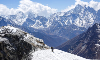
If we follow Plan A, we depart from High Camp just before daybreak for the Lobuche East summit attempt. The ascent from High Camp to the summit usually takes between 3 and 4 hours depending on pace, conditions, and traffic on the route. From camp, we head north beneath the summit toward the start of the first fixed rope.

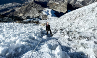
The exit from High Camp is one of the most technically demanding sections of the climb because of the ice on the rocks. The good news is that we will have trained on this exact section the previous day. From there, we exit the rocky couloir onto a snow slab where clear steps are often dug into the snow and ice by previous climbers.

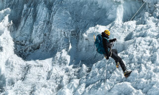
The fixed ropes are easy to follow and help guide our way, but it is important not to rely on them to pull yourself up. The aim is to use your feet, balance, and the techniques practised during training. This is more efficient, conserves energy, and is safer. The fixed ropes are there to assist. They are not there to climb for you.

The route continues across four consecutive fixed rope sections, each roughly 100 meters in length. At the top of the final rope in this series, we reach a plateau of snow and ice just a few meters below the summit. The narrow summit ridge and the slightly steeper section used to gain the ridge can create a bottleneck, especially in busier seasons. If needed, we may wait on the plateau until the summit ridge is clear and safe to access.

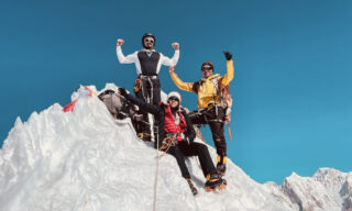
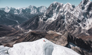
From the plateau, it takes less than 10 minutes to reach the summit. Once on the ridge, the Everest range opens up again in full force. From the summit of Lobuche East, it is possible to see the 8000 meter giants of Shishapangma, Cho Oyu, Everest, Lhotse, and Makalu. It is an incredible moment and one of the most powerful summit views in the Khumbu.

We will try to spend as much time as conditions allow on the summit, taking photos and appreciating the achievement. Weather, temperature, wind, timing, and other climbers may limit how long we can stay. Either way, we still have a significant descent ahead of us, so we begin moving down as soon as the climbing guides decide it is time.

The descent follows the fixed rope system back toward Higher Camp. We may need to abseil to access the plateau at the start of the descent, and extra care is needed on the final icy rock section before returning to camp. In some conditions, abseiling may also be the safest option there. Your climbing guides will remain close throughout the technical sections, advising on rope technique, movement, abseiling, spacing, and descent decisions so the team can move as safely and efficiently as conditions allow.

Once back at camp, we have a second breakfast, pack up our tents, and begin descending the rock slabs toward Lower Camp. The descent to Lower Camp is usually faster than the ascent because we are moving into lower altitude and higher oxygen levels. Depending on our arrival time, we may have a snack or lunch before continuing down toward Pheriche. Lunch is usually taken at the tea houses of Thukla.

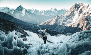
After some rest, we continue along a descending trail that differs from the route we used on the way up. The descent drops altitude quickly before opening into an easier, flatter walk near the north faces of Cholatse and Taboche. Ama Dablam comes back into view ahead of us, while Lobuche East stands clearly behind us.

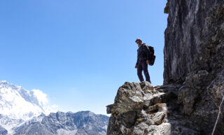
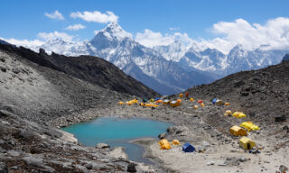
At the end of the valley is Pheriche, our home for the evening. Pheriche is a key hub for high altitude expeditions because of its clinic and helicopter access. It is also where the body begins to feel the relief of lower altitude again. There are a few coffee shops to visit, and life slowly starts to feel a little more comfortable as we return toward the lower Khumbu. Dinner will be at our tea house.

DAY 15: PHERICHE DESCENT TOWARD TENGBOCHE AFTER LOBUCHE EAST

Distance: 10.5 KM | Ascent: 323 M | Descent: 766 M | Max Altitude: 4,371 M


For those who have selected the optional high altitude helicopter return from the trail, this may be the point where your shortened descent begins, depending on the confirmed landing point, weather, aircraft availability, and operational conditions. This is separate from the included Kathmandu to Lukla or Lukla to Kathmandu aviation sector. If the high altitude helicopter return is used, the LHO team will confirm the exact routing, handover, and hotel transfer arrangements before departure and again during the expedition.

For the rest of the team, we begin after breakfast by reconnecting with the trail that follows the Khumbu River in the direction of Ama Dablam. As the valley starts to steepen, the trail veers to the right and follows an embankment that reconnects with the ascending trail toward Dingboche. We continue along the descending route until we reach the familiar village of Pangboche, where we stop for lunch and take time to enjoy the borderland feel between the greener lower valley and the dazzling white peaks of the upper Khumbu.

After lunch, we resume the descent along the stairs that lead to the suspension bridge on the edge of the rhododendron forest. The most challenging part of the day is often the final ascent through the forest to the pass where Tengboche Monastery sits. Depending on the pace of the team, it may be possible to descend beyond the monastery to tea houses closer to Namche Bazaar. Our trekking team will assess the conditions closer to the time and brief the group on the final destination.

DAY 16: TREK FROM TENGBOCHE TO NAMCHE BAZAAR AND MONJO

Distance: 14.5 KM | Ascent: 688 M | Descent: 1,685 M | Max Altitude: 3,860 M


Tengboche is the last truly remote village along this part of the trail, and nothing makes that contrast clearer than leaving the monastery behind and passing through Namche Bazaar later in the day. Both places are beautiful in their own way, but they feel completely different. Tengboche carries the quiet atmosphere of the upper Khumbu, while Namche brings us back into the movement, colour, and trade of the lower valley.

The trail begins with a long descent to the valley floor before crossing a series of suspension bridges and ascending through pine forest toward the junction between the Khumbu and Gokyo valleys. We’ll stop at a tea house in the forest for a short break before continuing toward the high point of the day. This is the final major ascent of the expedition.

As we approach Namche, we begin to see small market stalls along the trail and the familiar sight of donkey caravans, which gradually replace the yaks used higher up the valley. From there, it is a short walk into Namche Bazaar, where we stop for lunch. Depending on our pace, there may be time to roam around before we continue our descent through the forest, cross the Tenzing Hillary Suspension Bridge, and reach the valley floor where the village of Monjo awaits.

Our night will be spent at a tea house in Monjo.

DAY 17: TREK FROM MONJO TO LUKLA AND FINAL NIGHT ON THE TRAIL

Distance: 12.6 KM | Ascent: 722 M | Descent: 715 M | Max Altitude: 2,835 M


The end of the trail is the Sherpa village of Lukla, home to Tenzing Hillary Airport. Monjo is only a few hours from Lukla, which gives us some flexibility if weather conditions suggest that flying out earlier may be the better plan. Because the expedition includes one helicopter sector between Kathmandu and Lukla, the final aviation plan will depend on how the inbound journey was operated and what conditions allow. If the helicopter sector has not yet been used, it may be used from Lukla to Kathmandu to reduce the risk of delay. If it was used on the way in, the return from Lukla is usually by fixed wing flight, subject to weather and airport operations.

Assuming conditions are favourable, we start slowly after breakfast and take our time moving through the villages along this final section of the trail. We passed through many of them on the way up, but the mindset is different now. With the main objective behind us, there is more space to enjoy the rhythm of the valley, the tea houses, the people, and the final steps of the expedition.

Lunch will be in Phakding along the trail, with plenty of opportunities to stop for tea and coffee along the way. The final push to Lukla is a mild challenge as we ascend a series of stairs and village trails toward the entrance of town. The afternoon is free to explore the coffee shops, pubs, markets, and stores.

We’ll spend our last night on the trail at a local tea house in Lukla, where we’ll also share our final trail dinner.

DAY 18: RETURN FROM LUKLA TO KATHMANDU

Hot showers await us on our return to Kathmandu. Depending on how the journey into Lukla was operated, today may involve either the included helicopter sector from Lukla to Kathmandu or the fixed wing flight back toward Kathmandu. The decision is made according to weather, airport operations, and the best available plan for the group.

Patience is key when it comes to aviation in Nepal, although including one helicopter sector gives us more flexibility around one of the most unpredictable parts of the expedition. Depending on when we move, lunch may be in Lukla, Kathmandu, or the alternative airport sometimes used to manage Lukla air traffic into Kathmandu.

Wherever we finally land, the LHO team will do everything possible to get you to the hotel smoothly so you can shower, rest, and enjoy Kathmandu before our farewell dinner.

DAY 19: DEPARTURE FROM KATHMANDU AFTER THE LOBUCHE EAST EXPEDITION

The last day together is dedicated to airport transfers and farewells. Breakfast is included before departure.

Please make sure to provide the correct departure details when completing your Team Details Form before the trip begins so the transfer arrangements can be planned properly. We usually arrange your airport shuttle around 3 hours before departure, so please stay close to the hotel at the confirmed time to avoid delays.

For those departing later in the day, the LHO team will be happy to recommend places to visit or help arrange a city tour if you were not able to join one earlier in the trip. Your LHO Team Leader will be available in Kathmandu to support departure arrangements. Please communicate any changes to your flight details as soon as possible so the final transfer plans can be updated smoothly.

CAN’T TAKE THIS MANY DAYS OFF?

It is possible to shorten this trip by adding an optional high altitude helicopter return from the trail after the main climbing objective, subject to weather, landing conditions, aircraft availability, and the confirmed itinerary. This is separate from the included Kathmandu to Lukla or Lukla to Kathmandu aviation sector. Ask us about the shorter itinerary by reaching out to info@lifehappensoutdoors.com.

OUR COMMITMENT

OUR COMMITMENT

We are dedicated to ensuring that everyone involved in our services receives a fair living wage in their respective countries. We invest in our team members, fostering upward mobility within the adventure travel industry, expanding educational opportunities, and offering support wherever we can. By joining an LHO adventure you are directly impacting the incredible people and the remote communities that make these life-changing experiences possible.

LEARN MORE
HEALTH & SAFETY GUIDELINES

HEALTH & SAFETY GUIDELINES

We do our best to ensure your wellbeing on LHO adventures. That's why the facilities we use throughout our trips are required to meet our health and safety standards. We also follow the laws and protocols of every country that hosts our adventures. This extends to national regulations requiring Covid-19 testing, vaccination certificates, mask wearing or any other local guidelines that may apply. Contact us for the most up to date protocols related to your destination.

LEARN MORE

Highlight Video

Not sure what you are looking for?

CHECK ALL ADVENTURES CHAT WITH US

Lobuche East Expedition Frequently Asked Questions

Where is Lobuche East?

Lobuche East is located just southwest of Mount Everest, nestled between the Khumbu Valley and Gokyo Valley. It is a freestanding peak, and from its summit, you can enjoy the best unobstructed view of Mount Everest, making it a truly iconic destination for those looking to climb Lobuche peak.

Why is it called Lobuche East?

The name Lobuche East refers to the eastern peak of the Lobuche Peak massif. It is one of the two summits of the Lobuche massif, the other being Lobuche West. The Lobuche East peak climb is a popular mountaineering objective for trekkers seeking a challenging ascent in the Everest region, offering a thrilling opportunity to summit a 6,000-meter peak.

When is the best time to climb Lobuche East?

The best times to climb Lobuche East are during the spring (March to May) and autumn (late September to November). These seasons offer clear skies, stable weather conditions, and better visibility, making it ideal for the Lobuche East climb. The weather is not only favourable for climbing but also for trekking to Gokyo Lakes and Cho Lo Pass for acclimatisation.

How hard is Lobuche East?

Lobuche East is considered a challenging climb, suitable for trekkers with some mountaineering experience. It requires skills such as using crampons, ice axes, and fixed ropes on steep sections. The climb to the Lobuche East summit involves a long ascent with technical sections, making it more demanding than a basic trek to Gokyo Lakes. Preparation in high-altitude trekking and basic mountaineering techniques is essential for a safe ascent.

How fit do I need to be to climb Lobuche East?

LHO rates the Lobuche East climb as Enduring, meaning it requires a good level of physical fitness and mental resilience. Regular high-aerobic endurance and strength training are crucial when preparing for this challenging Lobuche East peak climbing adventure. Here are some key recommendations to include in your workout routine:

Cardio: Running, hiking, trail running, uphill treadmill walking, stair climbing, swimming, or cycling to build cardiovascular endurance.

Strength: Focus on push-ups, squats, lunges, and planks to develop leg and core strength.

Flexibility: Incorporate yoga to maintain flexibility and prevent injuries.

Interval Training (HIIT): High-intensity interval training to boost endurance, agility, and recovery.

Mental Resilience: Prepare mentally for the challenges of high-altitude climbing with techniques like ice baths, meditation, and isometric holds to build stress management and focus.

We recommend dedicating 3 to 4 days a week to specific training for the Lobuche East climb to ensure you are well-prepared for the demands of this incredible mountaineering experience.

How high is Lobuche East?

Lobuche East stands at an elevation of 6,189 meters (20,305 feet) above sea level. It is one of the most sought-after trekking peaks in Nepal, offering both technical challenges and incredible views of the surrounding peaks, including Mount Everest, Lhotse, Makalu, and Cho Oyu.

I've never been mountaineering. Can I join the Lobuche East Expedition?

Yes! Our Lobuche East climb expedition is designed to accommodate first-time mountaineers. Basic mountaineering training is provided as part of the expedition, covering essential skills like using an ice axe, crampons, and ascending and descending fixed ropes. If you’re fit and have high-altitude trekking experience, this expedition is a great introduction to Himalayan mountaineering.

What's the accommodation like on the Lobuche East Expedition?

Accommodation during the Lobuche East climb expedition varies depending on the location. In Kathmandu, we stay in comfortable, carefully selected hotels offering modern amenities. Along the trek, we stay in traditional tea houses with basic facilities like shared bathrooms, communal dining areas, and limited power outlets. At Lobuche East Base Camp, we stay in mountaineering tents for the duration of the climb.
On the Gokyo trail, we stay in tea houses. These are basic family-run accommodations that are very much part of the experience when trekking in the Himalayas. They consist of shared bathrooms, showers, and a restaurant. We do not sleep in tents at any point on this adventure.

At Lobuche Base Camp and the forward camps along the mountaineering portion of this expedition, we will be staying in technical tents.

How can I charge my devices and power banks? Do tea houses charge for using electrical outlets?

You can charge your devices in the tea houses along the trek. However, power outlets are limited, and demand for them is high. Most tea houses will charge a small fee, typically between 200 to 500 Nepali Rupees ($2 to $5 USD), to charge your power bank or devices. It’s a good idea to bring multiple power banks and use any available opportunity to keep them charged.
At the base camp charging is not possible. Our last opportunity to charge will be at the last tea house. Consider having enough power bank capacity for three days without recharging.

How much should I carry as spending cash?

For the Lobuche East expedition, we recommend carrying around $200 USD for personal expenses such as snacks, charging fees, and small souvenirs along the trek. Additionally, the suggested tipping amount for the guides and support team is around $350 USD, which can be shared between the climbing crew and other support staff.

I've heard some expeditions don't go to the real summit of Lobuche East?

While we aim to reach the main summit of Lobuche East, it’s important to note that there are no guarantees on where a climber will reach due to factors like weather, safety concerns, or individual pacing. Our goal is to summit the true peak, but the decision ultimately depends on conditions and the group’s progress. We prioritize safety and ensure that all climbers have a fulfilling and challenging experience during their Lobuche East climb.

Lobuche East Expedition Frequently Asked Questions

Will my Lobuche East Expedition be led by an LHO Team Leader?

Yes. Your expedition is shaped by an LHO Team Leader, who will be present and available for Kathmandu based events, including arrival, the welcome briefing, team dinners, and departure support. Their role is to set the tone of the experience, support the group, and help create the seamless logistics, rhythm, and attentive care Life Happens Outdoors is known for. On the trail, you are guided by our expert Khumbu trekking team, while the Lobuche East climb itself is led by certified high altitude climbing guides. Their knowledge of the route, altitude, glacier travel, fixed ropes, summit timing, and mountain conditions is central to the expedition.

Who leads the Lobuche East summit climb?

The Lobuche East summit climb is led by certified high altitude climbing guides. Your climbing guides manage the technical training, equipment checks, glacier movement, fixed ropes, crampon technique, summit timing, spacing, safety decisions, and descent. This matters because Lobuche East is not just a trek. It is a real Himalayan climb above 6000 meters with technical mountain terrain, fixed rope systems, abseiling, and a narrow summit ridge.

Is a helicopter transfer included on the Lobuche East Expedition?

Yes. Our Lobuche East Expedition includes one helicopter sector between Kathmandu and Lukla, used either on the way into the mountains or on the way back from Lukla depending on weather, flight operations, and the best plan for the group. The other airport sector is usually completed by fixed wing domestic flight. This gives us more flexibility around Lukla, where delays are common.

This included helicopter sector applies only to Kathmandu to Lukla or Lukla to Kathmandu. Any helicopter return from higher on the trail, including after the Lobuche East climb, remains a separate optional add on, subject to weather, landing conditions, aircraft availability, and the confirmed itinerary.

Where is Lobuche East?

Lobuche East is located just southwest of Mount Everest, nestled between the Khumbu Valley and Gokyo Valley. It is a freestanding peak, and from its summit, you can enjoy the best unobstructed view of Mount Everest, making it a truly iconic destination for those looking to climb Lobuche peak.

Why is it called Lobuche East?

The name Lobuche East refers to the eastern peak of the Lobuche Peak massif. It is one of the two summits of the Lobuche massif, the other being Lobuche West. The Lobuche East peak climb is a popular mountaineering objective for trekkers seeking a challenging ascent in the Everest region, offering a thrilling opportunity to summit a 6,000-meter peak.

When is the best time to climb Lobuche East?

The best times to climb Lobuche East are during the spring (March to May) and autumn (late September to November). These seasons offer clear skies, stable weather conditions, and better visibility, making it ideal for the Lobuche East climb. The weather is not only favourable for climbing but also for trekking to Everest Base Camp and Kala Patthar for acclimatisation.

How hard is Lobuche East?

Lobuche East is considered a challenging climb, suitable for trekkers with some mountaineering experience. It requires skills such as using crampons, ice axes, and fixed ropes on steep sections. The climb to the Lobuche East summit involves a long ascent with technical sections, making it more demanding than a basic trek to Everest Base Camp. Preparation in high-altitude trekking and basic mountaineering techniques is essential for a safe ascent.

How fit do I need to be to climb Lobuche East?

LHO rates the Lobuche East climb as Enduring, meaning it requires a good level of physical fitness and mental resilience. Regular high-aerobic endurance and strength training are crucial when preparing for this challenging Lobuche East peak climbing adventure. Here are some key recommendations to include in your workout routine:

Cardio: Running, hiking, trail running, uphill treadmill walking, stair climbing, swimming, or cycling to build cardiovascular endurance.

Strength: Focus on push-ups, squats, lunges, and planks to develop leg and core strength.

Flexibility: Incorporate yoga to maintain flexibility and prevent injuries.

Interval Training (HIIT): High-intensity interval training to boost endurance, agility, and recovery.

Mental Resilience: Prepare mentally for the challenges of high-altitude climbing with techniques like ice baths, meditation, and isometric holds to build stress management and focus.

We recommend dedicating 3 to 4 days a week to specific training for the Lobuche East climb to ensure you are well-prepared for the demands of this incredible mountaineering experience.

How high is Lobuche East?

Lobuche East stands at an elevation of 6,189 meters (20,305 feet) above sea level. It is one of the most sought-after trekking peaks in Nepal, offering both technical challenges and incredible views of the surrounding peaks, including Mount Everest, Lhotse, Makalu, and Cho Oyu.

How technical is Lobuche East?

Lobuche East is a serious Himalayan climbing objective. The climb involves high altitude, crampons, ice axe use, fixed ropes, glacier travel, abseiling, and a summit ridge above 6000 meters. It is suitable for strong trekkers who want to progress into mountaineering, but it should not be treated as a simple trek. The summit phase is led by certified high altitude climbing guides, and the expedition includes technical training before the climb.

I've never been mountaineering. Can I join the Lobuche East Expedition?

Yes! Our Lobuche East climb expedition is designed to accommodate first-time mountaineers. Basic mountaineering training is provided as part of the expedition, covering essential skills like using an ice axe, crampons, and ascending and descending fixed ropes. If you’re fit and have high-altitude trekking experience, this expedition is a great introduction to Himalayan mountaineering.

What is the accommodation like on the Lobuche East Expedition?

During the Lobuche East Expedition, accommodation varies between Kathmandu hotels, mountain tea houses, and technical tents at Lobuche Lower Camp or Higher Camp. In Kathmandu, we use carefully selected hotels that blend comfort, location, and local character, with easy access to markets, restaurants, and walking areas.

On the trail, we stay in tea houses, which are locally run mountain lodges and a central part of trekking in the Himalayas. Tea houses become simpler as we move higher into the Khumbu, but we select the best available standard where possible. In Namche Bazaar, and in Gokyo where applicable, we use stronger available accommodation to give you better comfort, atmosphere, and recovery during key acclimatisation points.

For the Lobuche East climb itself, we transition to technical mountaineering tents at Lower Camp or Higher Camp. This is a more basic expedition environment, but it places the team where it needs to be for training, rest, and the summit push.

How can I charge my devices and power banks? Do tea houses charge for using electrical outlets?

You can charge your devices in the tea houses along the Everest Base Camp trek. However, power outlets are limited, and demand for them is high. Most tea houses will charge a small fee, typically between 200 to 500 Nepali Rupees ($2 to $5 USD), to charge your power bank or devices. It’s a good idea to bring multiple power banks and use any available opportunity to keep them charged.
At the base camp charging is not possible. Our last opportunity to charge will be at the last tea house. Consider having enough power bank capacity for three days without recharging.

How much should I carry as spending cash?

For the Lobuche East expedition, we recommend carrying around $200 USD for personal expenses such as snacks, charging fees, and small souvenirs along the trek. Additionally, the suggested tipping amount for the guides and support team is around $350 USD, which can be shared between the climbing crew and other support staff.

I've heard some expeditions don't go to the real summit of Lobuche East?

While we aim to reach the main summit of Lobuche East, it’s important to note that there are no guarantees on where a climber will reach due to factors like weather, safety concerns, or individual pacing. Our goal is to summit the true peak, but the decision ultimately depends on conditions and the group’s progress. We prioritize safety and ensure that all climbers have a fulfilling and challenging experience during their Lobuche East climb.

Is the high altitude helicopter return included?

No. The high altitude helicopter return from the trail is not included in the standard Lobuche East Expedition price. It is an optional paid add on for those who want to shorten the descent after the climb or after another suitable point in the itinerary. This is separate from the included Kathmandu to Lukla or Lukla to Kathmandu aviation sector.

Discover More

A First-Timer’s Guide to Mountaineering Gear

How To Transition From Hiking to Climbing

The LHO Summit Record Revealed!

PAYMENT PLANS AVAILABLE

FROM $12,431,370

$11,436,860
on selected dates only

DOWNLOAD YOUR TRIP GUIDEBOOK

This field is for validation purposes and should be left unchanged.
Name(Required)
This field is hidden when viewing the form
TELL YOUR FRIENDS
An adventure holiday for anyone with a pulse. No fitness requirements or prerequisites. Come as you are. Great for those who already train 1-2 times per week or would like to use this upcoming adventure as an opportunity to kickstart a fitness journey. Joiners should be comfortable with their physical fitness and regularly train at least 2-3 times a week in the lead up to this adventure. Joiners should be comfortable with their physical fitness and regularly train at least 2-3 times a week in the lead up to this adventure.Joiners should be comfortable with their physical fitness and regularly train at least 2-3 times a week in the lead up to this adventure. Need we explain further? No prior experience is required. Basic skills may be taught during this adventure. The skills necessary to safely complete this adventure will be taught as a part of this experience. This adventure requires prior experience, pre-requisite skills or certifications. See below for details. We aim to strike a balance between unique local experiences and international standards of comfort and hygiene. Hostels are dorm-style accommodation used during certain legs of our trips and expeditions. They can be quite trendy with common areas, restaurants and cafes. Expect rooms to include a bed and a mattress as well as a common dining area with chairs and tables. You’ll need to bring a sleeping bag and an optional pillow. When the experience includes camping we provide the tents, sleeping mats, common dining tents, camping chairs and camping tables. The only thing you’ll need to get is a sleeping bag and an optional camping pillow. Please refer to the LHO gear list for more information specific to the trip you’re on. Mountain Lodges are usually well equipped, providing beds with duvets and pillows. They also include a common restaurant area. Some lodges require a sleeping liner.

Invite & Earn

X
Signup to start sharing your link
Signup
background banner image
loading gif

Available Coupon

X
Select your currency