Enduring The Alps

TRIP TYPE
Summit

DURATION
7 Days

DESTINATION
The Alps
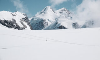
Spanning the Swiss-Italian border, our LHO expedition to Monte Rosa's summits is named after the Italian mountain huts serving famous Spaghetti. Starting and ending in Zermatt, the Swiss resort town, our expedition provides a complete experience, avoiding any retracing of steps. It grants access to all summits, enabling us to savor the region's finest without cutting corners.
1
An all inclusive alpine mountaineering experience featuring basic training and alternative routes during adverse weather, at no extra cost.
2
Relive the adventure with exclusive expedition photography captured by your LHO Team Leader, included as part of our standard offering.
3
Guided by a specialised LHO Expedition Coordinator and certified IFMGA guides, ensuring a seamless, safe experience, with full support on and off the mountain.


2026
DATE & STATUS
PRICE
TEAM LEADER
AVAILABILITY
WHAT'S INCLUDED IN THIS TRIP
WHAT'S NOT INCLUDED IN THIS TRIP
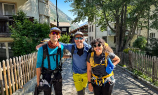
DAY 1: ARRIVING IN PICTURE-PERFECT ZERMATT
The first day of our adventure is dedicated to arrivals. Rail transfers from Geneva Airport to Zermatt are included within the itinerary, provided your flight arrives before 5:30 pm. If your flight lands after that, please coordinate your arrival with the LHO Base Camp Team, as the mountain train to Zermatt stops operating. We’ll be able to help book a taxi for the Visp-Zermatt leg of the journey.
The meeting point is Zermatt Bahnhof (train station), where your LHO Team Leader will be waiting to welcome you. It’s a short walk to our hotel from there, where we’ll get you checked in, perform a gear check, and head out to rent any items you may be missing. Check-in starts at 3 pm, but we can store our bags at the hotel and roam around if we arrive early. We highly recommend arriving early to rent gear on arrival day. This makes things much easier for you on the following day. The gear stores close at 7 pm. Your LHO Team Leader will send you a list of stores, markets, restaurants, and cafes to visit if it’s closer to your arrival time.
The first scheduled event of our adventure is a team dinner hosted by Your LHO Team Leader and local lead guide in town at 7:30 pm. This will be your first opportunity to meet everyone, receive a detailed briefing of the epic adventure ahead of us, and ask any questions you may have. First round of drinks is on us!
DAY 2: THE GLACIER PARADISE
Distance: 8.9 KM | Ascent: 625 M | Descent 977 M | Max Altitude: 4,164 M
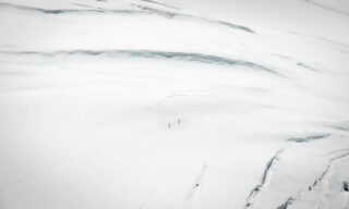
The potential 4000-meter summits to bag on our first day are the Breithorn and Central Breithorn. We’ll get an early start after breakfast, heading in the direction of the Matterhorn Express cable car. For those of us carrying extra luggage, we can store our bags in the lockers of the hotel until we return. The cable cars are an adventure unto themselves, with views of the Matterhorn, the Weisshorn, the entire Monte Rosa range, and the Mischabel range. If that’s all gibberish to you, we’re talking about the largest concentration of iconic 4000-meter summits anywhere in the Alps!
BREITHORN
Upon arriving at the Klein Matterhorn station, above 3800 meters, the highest cable car station in the Alps, we’ll go over some of the basic skills needed for the first day before tackling the Breithorn. This summit is widely considered the easiest 4000-meter summit. It’s the perfect learning opportunity and will enable us to begin with the basics. The trail begins at the cable car station and initially follows the groomed piste of the ski resort. After about 100 meters beneath the ski lift, the trail departs from the confines of the resort and connects with a wide glacial plateau. The giants of the Monte Rosa will become clearly visible in front of us, with views as far as the Lyskamm, Pollux, and Castor summits. The gradual ascent to the Breithorn starts at the end of the plateau, where we’ll be met by two switchbacks that span the entire length of the east face of the mountain. The summit is at the top of the second switchback, where the ridge becomes slightly narrower. If our skills and energy level permit, we may even be able to traverse over to the second summit known as the Central Breithorn before we descend.
CENTRAL BREITHORN
The traverse is slightly more challenging than achieving the main summit because it follows a narrower ridge and a slightly steeper ascent to the summit.
With two summits above 4000 meters in the bag, we’ll descend the expansive glacier below in the direction of the Val d’Ayas. Lunch will be a picnic along the descending trail where it is safe to stop. We are now fully inside Italy! The refuge sits on an exposed rock surrounded by a glacier. Dinner will be at the mountain hut.
DAY 3: CASTOR, POLLUX & FELIKHORN
Distance: 6.1 KM | Ascent: 976 M | Descent: 781 M | Max Altitude: 4,205 M
The potential 4000-meter summits to bag are the Pollux, Castor, and Felikhorn. The route necessitates the summiting of Castor and its sister summit along the same ridge known as Felikhorn. For those of us who have a bit more experience, it may be possible to traverse the technically demanding Pollux.
POLLUX
We will depart the hut in the early hours and ascend the glacier in an easterly direction. For those of us climbing Pollux, the trail will bank left and approach the rocky southwest ridge. From there, we’ll ascend the ridge through a series of easy grade scrambling, although ice on the rocks can make this much more challenging. Just below the summit are two pitches of grade climbing that are equipped with chains to assist us in overcoming this steep section. It is likely that we will pitch these two sections for safety.
Once we complete the two rock pitches, we will find ourselves on the final push along a glacial ridge that directly leads to the summit. From the summit, we will traverse across and begin our descent along the east ridge. The views here are incredible, with the Monte Rose glacier just beneath our feet and the summits of the Duforspitze, Zumsteinspitze, Lyskamm, and Castor surrounding us. The descent is straightforward and requires some sure-footedness, particularly on sections of loose rock. Once back on the glacier, we will follow the trail that climbs up the east face of Castor.
CASTOR-FELIKHORN
Similar to the Breithorn, this trail is formed of switchbacks but along a much steeper gradient. The final access to the summit ridge can be steep when the snow cover recedes, exposing the ice beneath. In this instance, it may be desirable to pitch once again for safety. The final ridge to the summit is sharp and requires tremendous concentration and sure-footedness, especially when there are gusts of wind. Once at the top, we’ll continue along the ridge line as it goes down and reconnects with another ascent to the summit of Felikhorn. From there, the ridge widens substantially. Our picnic lunch will be on the wide plateau after the summit. From there, the descent is straightforward, following a path along the glacier that eventually reaches the Quintino Sella hut, our home for the night. That’s five potential summits now in the bag and two spaghetti dinners!
DAY 4: THE NASO DEL LYSKAMM
Distance: 10 KM | Ascent: 1,071 M | Descent 1,051 M | Max Altitude: 4,344 M
The potential summits for the day are the Naso Del Lyskamm, Balmenhorn, and Piramide Vincent. The Naso Del Lyskamm is an impressive face that we must traverse in order to access the sector of the Monte Rosa Massif that includes the highest summits. Commonly known as just the “Naso,” the objective challenge of this section is scaling the icy face that often requires pitching and can be time-consuming. That’s why an early start is paramount.
NASO
We’ll depart the Quintino Sella hut in an easterly direction, staying below the south side of the Felikhorn. The trail connects with a massive glacier that banks left beneath the south-facing walls of the Lyskamm. The glacier traverse is relatively flat as we approach the Naso. The access to the summit begins along a rocky ridge usually covered in ice. The steep gradient is automatically felt, and the higher we go, the steeper it becomes until we are required to front-point with our crampons to ascend. Unless conditions are extremely favorable, and it is determined that the team has the necessary skills to short rope this section, we will pitch up to four belay stations to ascend the face safely. By the fourth pitch, the incline will start to become milder until we finally reach a series of short switchbacks that lead to the even shorter summit ridge. Depending on the wind, it may be possible to have a picnic just beneath the summit on the opposite side, where the views of an entirely new region of the Monte Rosa become visible. On a clear day, we’ll be able to see deep into the Italian Alps and sometimes even as far away as the Mon Viso in Piemonte!
The descent of the Naso is much easier than the ascent and follows a walkable trail until we reach the glacier. From there, it’s possible to either head directly to Gniffeti hut or to bag two more summits. These summits are situated near one another. It isn’t necessary to do all two either.
BALMENHORN
Assuming both are targeted, we’ll begin with Balmenhorn being the highest in altitude between the two and the furthest away from the hut. The trail is largely a long glacier walk along a mild incline. Balmenhorn is a rock that sticks out of the glacier. We’ll approach the summit from the west face, where a ladder has been built into the rock to assist climbers with accessing the summit. It’s a short climb to reach the top, where the Italian Alpine Club has even built a shelter for climbers caught out in bad weather. The exit from the summit is a retracing of our steps down the ladders to the glacier, where we’ll connect to the snow ridge that descends in the direction of the impressive Piramide Vincent.
PIRAMIDE VINCENT
The trail to Piramide Vincent from the col is milder than the Breithorn but with a full day behind us, it can feel gigantic. The trail follows a moderate ascent along three switchbacks to the summit. From there, we’ll descend back to the col and then continue descending along the long glacier all the way down to Gniffeti hut, our home for the evening. That’s 8 summits and 3 spaghetti dinners done!
DAY 5: SUMMIT BAGGING ABOVE 4000
Distance: 13.4 KM | Ascent 1,198 M | Descent: 1,931 | Max Altitude: 4,573 M
Our last day at altitude is the most epic, with a potential four summits left to bag! These are the Ludwigshohe, Parrotspitze, Zumsteinspitze, and Signalkuppe, also known as Punta Gneffeti. We’ll start very early from Gniffeti hut with the ultimate aim of reaching Capanna Margherita situated on the summit of Signalkuppe (4,554m) and then descend to Monte Rosa Hutte on the Swiss side of the mountain. It’s also possible to climb Piramide Vincent and Balmenhorn if they weren’t tackled the previous day. It’s rare to bag them all, but it has happened on LHO trips before. The big target that we’ll all attempt to achieve is to reach Signalkuppe. We’ll begin with an ascent of the glacier in the direction of Col de Lys.
LUDWIGSHOHE
From the Col, it is possible to diverge from the main trail in order to climb Ludwigshohe, a very achievable and straightforward summit that involves only a mild ascent along a short ridge. From there, it’s a short traverse along the glacier in the direction of either the main trail to Signalkuppe or the start of the more challenging ridge traverse to the summit of Parrotspitze.
PARROTSPITZE
The access to the ridge is along a crevassed glacier that does require some attention. The ridge begins with a rocky section, usually covered in ice, somewhat similar to the Naso before connecting with a long and exposed snow ridge similar to the ridge of Castor. The summit sits at the center of the ridge, which continues to traverse eastwards until it connects with the wider glacier separating it from the Signalkuppe and Zumsteinspitze.
After descending the ridge, we’ll reconnect with the classic trail as it ascends moderately towards a flat basin. There is a big crevasse that is usually easy to spot as we top out onto the basin. From there, the choice is to either go directly to the Capanna Margherita on the summit of Signalkuppe or attempt the Zumsteinspitze, the second highest summit of the Monte Rosa massif after the nearby Duforspitze.
ZUMSTEINSPITZE
The summit trail follows the southwest ridge and starts with a wider snow ascent followed by a narrower ridge. The final section requires a little maneuver as we go around an awkward rock that covers the majority of the already narrow trail before finally achieving the summit. The views from here are pure magic. Almost all the summits of the Monte Rosa, including the Breithorn and Pollux from the very start of our experience, become visible. The gigantic Duforspitze is just a stone’s throw away. If only the ridge connecting Zumstein to Dufor wasn’t amongst the most challenging alpine achievements in this region.
We’ll descend from the summit using the same route to reconnect with the basin and traverse south in the direction of Signalkuppe.
SIGNALKUPPE – CAPPANA MARGHERITA
The last ascent involves one big switchback along an impressive incline. With everything that we’ve achieved so far, it should feel like a walk in the park. Albeit a park at 4,554 meters of altitude. We’ll take a long break inside the hut at the summit and eat our packed lunches. The aim is to recover as much as possible but keeping in mind that time works against our energy at altitude. At some point, being here will start to drain energy rather than enable recovery. Once we’re ready to head out, we’ll follow the same trail down to the basin, past the crevasse, and onto the classic trail facing Parrotspitze. Rather than returning to the Col de Lys, we will connect with a descending trail into Switzerland along the Monte Rosa glacier, losing altitude rapidly as the deeper snow gives way to the more exposed ice. Once the ice meets the dry trail, it becomes a short walk to the Monte Rosa Hutte, our last night in the mountains. That’s 12 summits in the bag, and since we’re back in Switzerland, no spaghetti on the menu (although sometimes it is spaghetti)!
DAY 6: BACK TO ZERMATT
Distance: 7.2 KM | Ascent: 386 M | Descent: 441 M | Max Altitude: 2,881 M
Our last day in the mountains won’t involve any summits but is a demanding day in its own right. After breakfast, we’ll connect with the trail that follows the Monte Rosa Glacier as it descends deeper and deeper into Switzerland. The iconic Gornergrat Observatory that forms part of the Zermatt ski area will come into clear view on the cliff top ahead. We’ll walk along the flat glacier until we start ascending beneath the Gornergrat along a gradual ascending trail that goes in a westbound direction. We’ll stop at one of the most iconic views in the Alps for our picnic, where the Matterhorn is straight ahead of us, and its reflection is clearly visible in the crystal-clear waters of the Riffelhorn Lake. From there, it is no more than a 10-minute walk to the Rotenboden train station, where we’ll board the mountain train down to Zermatt, where hot showers, market streets, and a celebratory team dinner await. Last drink of the trip is on us!
DAY 7: LEAVING ZERMATT IS NEVER EASY
Our final day together will be dedicated to airport transfers and farewells. Breakfast is included on this day. Please make sure that you provide us with the correct departure details when you fill out your Team Details Form prior to your adventure. If your itinerary has changed, please inform your Team Leader as early as possible for arrangements to be made.


OUR COMMITMENT
We are dedicated to ensuring that everyone involved in our services receives a fair living wage in their respective countries. We invest in our team members, fostering upward mobility within the adventure travel industry, expanding educational opportunities, and offering support wherever we can. By joining an LHO adventure you are directly impacting the incredible people and the remote communities that make these life-changing experiences possible.
LEARN MOREHEALTH & SAFETY GUIDELINES
We do our best to ensure your wellbeing on LHO adventures. That's why the facilities we use throughout our trips are required to meet our health and safety standards. We also follow the laws and protocols of every country that hosts our adventures. This extends to national regulations requiring Covid-19 testing, vaccination certificates, mask wearing or any other local guidelines that may apply. Contact us for the most up to date protocols related to your destination.
LEARN MOREWhat is the Spaghetti Tour?
The Spaghetti Tour is a high altitude mountaineering expedition designed to summit multiple 4000 meter peaks of the Monte Rosa massif in the Alps. Often referred to as the Spaghetti Tour of Monte Rosa, it is one of the most iconic routes in European mountaineering, offering a unique opportunity to climb several high summits in a single journey.
The name “Spaghetti Tour” comes from the series of Italian mountain huts along the route, where climbers stop for rest, food, and recovery between ascents. This adventure blends the thrill of climbing with the beauty of the alpine environment, making it a must for anyone looking to take on the Monte Rosa climb in a guided and supportive setting.
Where is the Spaghetti Tour?
The Spaghetti Tour takes place in the Monte Rosa massif and straddles the Swiss and Italian border, offering one of the most spectacular high altitude mountaineering experiences in the Alps. While most traditional Spaghetti Tour Monte Rosa itineraries start and finish in Italy, Life Happens Outdoors begins and ends the journey in Zermatt, Switzerland.
This approach allows us to complete a full semi circle around the mountain range without retracing any steps, making for a more immersive and rewarding experience. It also opens up the option for climbers who wish to include the Dufourspitze, the highest peak in Switzerland and part of the Monte Rosa climb, which is not typically included in standard Spaghetti Tour routes but can be added on.
Our final night is spent at the Monte Rosa Hutte, the mountain hut used to access Dufourspitze via the normal route, giving those who want to take on this extra objective a unique opportunity to do so.
Starting and ending in Zermatt also offers joiners the unique opportunity to enjoy Switzerland’s most iconic resort village, nestled at the foot of the legendary Matterhorn — a perfect beginning and end to this unforgettable journey.
Where do we sleep during the Spaghetti Tour?
During the Spaghetti Tour, the first and last nights are spent in comfortable hotel accommodation in Zermatt, giving you time to relax and enjoy the charm of Switzerland’s most iconic mountain village before and after your high altitude adventure.
While on the Spaghetti Tour of Monte Rosa, we stay in traditional mountain huts, which are dorm style accommodations featuring common toilets, a restaurant, and a bar area. These huts are an essential part of the alpine mountaineering experience and add to the unique atmosphere of the expedition.
Some of the most iconic huts on the Spaghetti Tour Monte Rosa route include Refugio Quintino Sella, Refugio Gnifetti, and the Monte Rosa Hutte. We also include a stop at the legendary Capanna Margherita, which at 4554 meters is the highest mountain refuge in the Alps.
How difficult is the Spaghetti Tour?
We rank the Spaghetti Tour as an enduring challenge, placing it in one of the higher categories of physical difficulty among all our experiences. The reason for this is that, unlike other expeditions such as the Mont Blanc summit course, there is no opportunity to descend to lower elevations for recovery. From the moment we depart Zermatt until we return, we remain in a sustained high altitude environment, with each day presenting as much physical challenge as the next.
That said, one of the unique aspects of the Spaghetti Tour of Monte Rosa is that it offers a level of adaptability. The itinerary can be adjusted to reduce or increase the number of summits tackled on the climbing days, allowing us to tailor the challenge based on the fitness level and ability of the group.
Whether you are pushing for all the peaks or pacing it more steadily, the Monte Rosa climb remains one of the most rewarding multi summit mountaineering experiences in the Alps.
How should I train for the Spaghetti Tour?
Training for the Spaghetti Tour is all about building a solid base of cardiovascular endurance and strength. The goal is to become comfortable with a high heart rate, since the Monte Rosa climb involves sustained effort at high altitude over several days.
The best way to prepare is by taking up activities that elevate your heart rate and help your body get used to that intensity. Spinning, for example, is an excellent choice — even though the effort on the trail won’t be quite as acute or fast paced, your body will feel more prepared when those challenging moments arrive.
Cardio training recommendations include running, cycling, swimming, spinning, hiking, rollerblading, or any activity that you find fun, sustainable, and accessible where you live. The more you enjoy your training, the more consistent you’ll be — and the better you’ll feel when you step into the mountains on the Spaghetti Tour of Monte Rosa.
Pilates or Yoga are great for training muscles to adapt to stress positions. Both of them enable your body to work as a whole unit with a focus on engaging the core.
Is the Spaghetti Tour suitable for beginners?
We run the Spaghetti Tour trip based on the assumption that our joiners have some experience with basic mountaineering. We do include some basic training but we do require that team members have some exposure to adventures of this nature prior to the start date.
The Spaghetti Tour is suitable for motivated beginners, but you will get the most out of the experience if you already have some basic mountaineering knowledge — such as walking with crampons, using a mountaineer’s ice axe, and moving as part of a rope party. While we do include basic training as part of the itinerary, having some familiarity with these skills will help you feel more confident and allow you to enjoy the journey more fully.
That said, this expedition is fundamentally more about physical conditioning than technical ability. Most of the Monte Rosa climb involves entry level terrain, and more advanced summits along the Spaghetti Tour route can be skipped if needed, offering flexibility based on the group’s comfort and ability.
With solid fitness and a willingness to learn, even those newer to alpine environments can take on this unforgettable challenge.
Do I have to carry all my stuff during the Spaghetti Tour?
Yes. During the Spaghetti Tour, you will carry your own gear throughout the expedition. There are no porters in the Alps, and a core part of the alpine experience is learning how to pack efficiently and be self sufficient with your equipment.
Having said that, if you follow the packing list, you should not need more than a 30 liter backpack for the duration of the experience. Your Life Happens Outdoors team leader and guide will be on hand to help you pack and ensure you are as light and efficient as possible, so you can move confidently and comfortably throughout the Monte Rosa climb.
PAYMENT PLANS AVAILABLE
FROM £4325
DOWNLOAD YOUR TRIP GUIDEBOOK


INQUIRE NOW
This adventure is only available as a private trip and is customized to your requirements, experience and skill level. To get started, please fill out the form below. We’ll be in touch soon to put it together for you.
"(Required)" indicates required fields
CONTACT US
We’re passionate about guiding you to epic adventures and beyond. If you have any questions at all, don’t hesitate to reach out. We’d love to hear from you.
JOIN THE LIFE HAPPENS OUTDOORS COMMUNITY!
Get £100 off your next adventure!
Sign Up To The Newsletter