EARLY BIRD! Enduring Nepal
Everest may be the headline, but the real adventure begins when you add an Island Peak climb to the journey. Rising to 6,189 meters, Island Peak transforms the Everest Base Camp trek into a true Himalayan climbing expedition. This 20 day itinerary combines careful acclimatisation through the Khumbu, the walk to Everest Base Camp, the option of Kala Patthar, technical training, Island Peak Base Camp, and a serious summit attempt guided by certified high altitude climbing guides. With LHO Team Leader support, expert Khumbu trekking leadership on the trail, specialist climbing leadership on the mountain, and one helicopter sector between Kathmandu and Lukla included, this is a powerful first Himalayan expedition for those ready to step beyond trekking.

TRIP TYPE
Climbing and Mountaineering

DURATION
20 Days

DESTINATION
Nepal
1
An all inclusive Island Peak Expedition combining the Everest Base Camp trek, Kala Patthar, Island Peak climbing and training, selected tea houses, high altitude tents and weather contingency.
2
Trip photography is included throughout the experience, giving you a lasting record of the Khumbu trail, Everest Base Camp, Island Peak Base Camp, and the mountain moments.
3
Your expedition includes one helicopter sector between Kathmandu and Lukla, used either inbound or outbound depending on conditions, to reduce the risk of Lukla flight disruptions.


2026
DATE & STATUS
PRICE
TEAM LEADER
AVAILABILITY
2027
DATE & STATUS
PRICE
TEAM LEADER
AVAILABILITY
WHAT'S INCLUDED IN THIS TRIP
WHAT'S NOT INCLUDED IN THIS TRIP
DAY 1: ARRIVAL IN KATHMANDU AND ISLAND PEAK EXPEDITION WELCOME BRIEFING
Kathmandu is an incredible, vibrant, and wild city that we’ve fallen in love with. That’s why we’re always so excited to receive you on the first day and share the gateway to the Himalayas with you.
On arrival day, you’ll be met by an LHO representative at the airport and driven to our centrally located hotel by private transfer. Navigating Kathmandu airport can be an adventure in and of itself, so you’ll receive a text with detailed instructions on how to efficiently make your way to us.
Your LHO Team Leader will be waiting to receive you at our hotel, help you settle in, and make sure you have everything you need for the adventure ahead. If you arrive early, your Team Leader will share a curated list of restaurants, coffee shops, heritage sites, and markets so you can make the most of your first day in Kathmandu.
Our first official event is a team dinner at 7:30 pm, hosted by your LHO Team Leader and local lead guide. This is where we meet the group, set expectations, answer questions, and begin building the rhythm of the journey together.
DAY 2: KATHMANDU CITY TOUR, GEAR CHECK AND LUKLA FLIGHT PREPARATION
Our first full day together gives us an opportunity to discover the magical city of Kathmandu, check our gear, and get to know each other before we head out to the trail. We’ll visit the nearby sites of Durbar Square and the Monkey Temple as well as get our first taste of Nepali cuisine during our team lunch.
Because aviation into the Everest region is highly weather dependent, the exact Lukla travel plan is confirmed close to departure. Your itinerary includes one helicopter sector between Kathmandu and Lukla and one fixed wing domestic flight sector between Kathmandu and Lukla. The helicopter may be used on the way into Lukla or on the way back from Lukla, depending on weather, airport operations, and the plan that gives the group the smoothest overall journey. Your LHO Team Leader will confirm the plan in Kathmandu and make sure everyone is clear before we leave for the mountains. Regardless, our team dinner will be at the accommodation we sleep at on the night.
DAY 3: TRAVEL TO LUKLA AND TREK TO PHAKDING
Distance: 8.7 KM | Ascent: 364 M | Descent: 521 M | Max Altitude: 2,860 M
Our day starts early as we make our way to the airport for the journey into Lukla, the gateway to the Everest region. Depending on conditions, this sector may be operated by helicopter or fixed wing flight. Your trip includes one helicopter sector between Kathmandu and Lukla, used either inbound or outbound, and one fixed wing domestic flight sector for the other direction. This gives us more flexibility around one of the most delay prone parts of the Everest Base Camp experience while keeping the trip sensibly priced.
Once in Lukla, we’ll be met by our porter team who will collect our duffle bags and take them to a local tea house where we’ll have lunch and prepare ourselves for the trek to Phakding. Lukla is one of the most vibrant villages in the Khumbu region. It’s an important hub of local and regional commerce as well as the border to the sacred high-altitude regions. Above Lukla, animal slaughter is religiously banned. That’s why we don’t recommend choosing any meat or chicken options above Lukla.
The trail begins at the entrance of the village and is actually mostly descending in the alpine forests and through the many towns that dot this section of the trail. The Tibetan influence and Buddhist character of the area are immediately apparent in the calligraphy, architecture, and religious stupas and shrines.
Our accommodation sits just above Phakding near the Khumbu river that is formed from the melting glaciers of the towering summits of the region, including Everest. In Phakding, we use one of the better available tea houses in the village, giving you a more comfortable first night on the trail while still keeping you fully connected to the atmosphere of the Khumbu.
Depending on our arrival time, it may be possible to explore the coffee shops and market streets of the village before dinner.
Our accommodation sits just above Phakding near the Khumbu River that is formed from the melting glaciers of the towering summits of the region, including Everest. Depending on our arrival time, it may be possible to explore the coffee shops and market streets of the village before dinner.
DAY 4: TREK FROM PHAKDING TO NAMCHE BAZAAR
Distance: 9.1 KM | Ascent: 1,095 M | Descent: 380 M | Max Altitude: 3,440 M
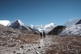
Our second day on the trail will be a full-on ascent to an impressive altitude of 3,445 meters, arriving at one of the most vibrant and remote high-altitude towns on the planet: Namche Bazaar. The trail begins by following the river and passes through the alpine forests. The trail is once again dotted by a series of villages and farming communities that add an incredible element of rural life to the walk.
Our first main objective is reaching the town of Monjo. This is the official entrance to the Sagarmatha National Park. There is a brief checkpoint where we present your permits to the authorities. Once through, we’ll descend a series of staircases flanked by Tibetan calligraphy carved into the rocks. We’ll stop for lunch at the last village in the valley before the direct ascent to Namche Bazaar. The trail to Namche is predominantly ascending and sustained. Our trekking team will set a slow, steady pace so we can manage the ascent to Namche efficiently without wasting energy unnecessarily.
Slow and steady is the name of the game here as we make our way up a series of stairs, cross the epic Tenzing-Hillary suspension bridge, and join the winding trail through the pine forest that leads to the village entrance. There’s a viewpoint of Everest halfway up to the top. On a clear day, this offers the first opportunity to see the world’s highest summit, albeit from afar. We’ll also use this as an opportunity to take a break and use the serviced bathrooms available there.
The reward at the end of our ascent is our arrival in the incredible Sherpa town of Namche, nestled between the towering summits of the high Himalayas. After checking into our tea house, we’ll have plenty of opportunities to explore the markets, coffee shops, and bars that give this place so much life. In Namche, we use one of the stronger available tea house options in the village, giving the group a more comfortable base for rest, acclimatization, and recovery before we move higher into the Khumbu.
This will be our home for the next two nights. Dinner will be at our tea house.
DAY 5: NAMCHE BAZAAR ACCLIMATISATION AND FIRST EVEREST VIEWS
Distance: 5.5 KM | Ascent: 503 M | Descent: 503 M | Max Altitude: 3,700 M
We’ll be staying in Namche Bazaar for a second night. That means we don’t have to repack our bags or check out from the Tea House. Our day will slowly start after breakfast. We’ll climb to the top of the town and visit the Sherpa museum where we can learn about the Sherpa culture, mountaineering history of the region, and about new sustainability practices that your visit to the region helps finance.
From there, we’ll trek to the hilltop high above the village to acclimatize by exposing ourselves to higher altitudes. The hilltop offers a jaw-dropping view of Everest, Lhotse, and Ama Dablam, three of the most iconic summits on the planet. We’ll be able to see all the way up the Khumbu valley and get a visual representation of what lies ahead of us.
There’s an opportunity for a short tea break at the Everest View Hotel nearby before we descend back to Namche for lunch at our Tea House and a free afternoon to enjoy the town. Dinner will also be at our Tea House.
This second night in Namche is also one of the places where our accommodation selection matters most, giving you a better chance to rest, recover, and enjoy the village before the trail becomes more remote.
DAY 6: TREK FROM NAMCHE BAZAAR TO TENGBOCHE MONASTERY
Distance: 9.4 KM | Ascent: 901 M | Descent: 454 M | Max Altitude: 3,860 M
If you’ve ever watched a movie or documentary about climbing Everest, then you’ve surely seen scenes from the Tyanboche monastery. This is where climbers come to receive a blessing of protection before ascending the giants of the region. The monastery is exactly where we’re heading.
After breakfast, we’ll depart in the direction of the Sherpa museum, but this time we’ll continue past it and follow the wide trail that heads straight down the valley. The trek is characterized by incredible photo opportunities, stupas, and the unlimited views of towering summits all around and the fewer villages that inhabit these parts. Although the trail does begin above the tree line, we will eventually start descending toward the valley floor, re-entering the thick forest and reaching the riverside once again.
We usually stop for tea along the descending portion of the trail and have a lunch break at the riverside. After lunch and a bit of rest, we begin the long ascent to Tengboche at a manageable pace set by our trekking team, helping the group arrive feeling strong. At 3:30 pm, the monastery opens for visitors, and we’ll have a chance to visit and participate in the rituals of one of Buddhism’s holy sites before dinner and rest at our Tea House.
DAY 7: TREK FROM TENGBOCHE TO DINGBOCHE ABOVE 4000 METERS
Distance: 10.6 KM | Ascent: 773 M | Descent: 279 M | Max Altitude: 4,410 M
The 4000-meter mark is universally considered the start of the high-altitude environment. Today is the day we’ll breach that ceiling and reach 4,400 meters. After breakfast, we’ll descend into a Rhododendron forest. The Rhododendron is the national flower of Nepal, and this forest has an incredible energy that really feels like a border between worlds.
We’ll emerge from the forest onto an iconic suspension bridge, which is where it’s possible to take a photo of trekkers walking above the mountain of Ama Dablam. Once we cross the bridge, we’ll start climbing a series of staircases with the summit of Ama Dablam immediately to our right.
The trail eventually enters the remote town of Pengboche, our lunch stop for the day. After a good meal and some rest, we’ll continue along the trail as it turns behind Ama Dablam and closer to the south face of Lhotse, the world’s fourth-highest summit. The forests are now replaced with limited short grass vegetation as the drier climate becomes more apparent.
Our final destination for the day is Dingboche, our home for the next two nights. Dingboche was once primarily herding grounds for yaks. The town has developed substantially over the past decades due to its position at the crossroads of the main climbing and trekking routes in the region. Dinner will be at our Tea House.
DAY 8: DINGBOCHE ACCLIMATISATION DAY
Distance: 3.1 KM | Ascent: 476 M | Descent 476 M | Max altitude: 4,600 M
We’ll be staying in Dingboche for two nights to rest and acclimatize. The Tea Houses in this area are relatively comfortable, giving us the opportunity to relax before pushing into the higher altitude environment.
Depending on the conditions and the spirits of the group, we may choose to take a short walk up to the pass to enjoy the views and acclimatize. This is completely optional, and it’s perfectly fine to choose not to exert yourself at all on this day. There are a few coffee shops worth visiting in the town, and we’ll also have plenty of free time to do that. Both lunch and dinner will be at our Tea House.
DAY 9: TREK FROM DINGBOCHE TO LOBUCHE VIA THE THUKLA PASS
Distance: 8.2 KM | Ascent: 951 M | Descent: 91 M | Max Altitude: 4,940 M
We’ll get an early start from Dingboche, departing after breakfast in the westerly direction. The close proximity of the mountains and glaciers is immediately apparent when we exit the town. On our left are the towering summits of the Cholatse and Taboche mountain ranges. Ahead of us is Lobuche. Behind us is Ama Dablam, and to our right is the south side of Lhotse and Nuptse. This area is full of wild yaks grazing in the open spaces.
The first portion of the trail is Nepali flat, which means it’s inclined but interrupted regularly by brief flat sections and even small descents. We’ll follow the trail until we reach a river crossing that can sometimes be a little tricky to navigate because of the regularly changing trails. Our trekking team will brief the group on staying together, particularly around the river crossing, where trail conditions can change regularly.
Once we cross the river, we’ll find a small cluster of Tea Houses known as Thukla. This will be the location of our lunch break for the day. After lunch, we’ll begin the ascent to the Thukla pass. Many people will describe this as the most challenging section of the trail. With a slow, sustained, and adaptive pace set by our trekking team, the climb to the Thukla Pass becomes much more manageable than many people expect.
The top of the trail is the infamous Thukla pass, home to the dedications to the many climbers who have died in the surrounding mountains, including Everest. This is a holy place for many, and although we can certainly take pictures, we should also be respectful to those of us who come here to mourn loved ones. After a break, we’ll follow the glacier moraine in the direction of Lobuche. It’s possible to see Pumori for the first time, an impressive 7000-meter mountain that stands freely in the shadow of nearby Everest. The Lobuche Tea Houses will gradually emerge from behind the northeast slopes of Lobuche summit, and we’ll make our way directly to our accommodation. Unlike previous villages, there are no more coffee shops or market streets. We are now in the wild outback of the Nepali Himalayas. Dingboche is the last village on this trail.
DAY 10: TREK TO EVEREST BASE CAMP AND OPTIONAL KALA PATTHAR
Distance: 13.3 KM | Ascent: 997 M | Descent: 312 M | Max Altitude: 5,364 M
Unlike traditional trekking groups, we choose to depart very early for our hike to Everest Base Camp. The reason for this is that we would like to give ourselves the opportunity to optionally climb Kala Patthar on the same day to catch the sunset on Everest. It is the sunset rather than the sunrise that is exceptionally beautiful from the top because we will be observing the mountain from its west face, which means the colors are most spectacular at sunset. The trail from Lobuche starts flat and is quite similar to the final stretches of our previous day. All that changes when we begin ascending the glacier moraine. The trail shifts dramatically from flat to incredibly hilly as we go up and down the terrain dug up by the glaciers. The trail even goes onto the glacier itself, albeit a section of the glacier almost fully covered by small stones. Once the trail starts to level out, it means we’re arriving at Gorak Shep, the final collection of tea houses before Everest Base Camp. We’ll stop there for tea, and it’s also possible to leave anything we don’t need for the final walk to base camp since we will be staying in the same place tonight. Once we’ve regained some energy, we’ll make our way out along the glacier’s side. The trail is less dramatic than the previous section with more easily navigable areas. The excitement is now super high as the base camp starts to become more and more visible ahead of us. As we approach, the towering summits of Nuptse and Pumori start to give way to the black summit pyramid previously concealed behind them. Mount Everest is finally revealed. From there, it’s a short descent onto the historic Khumbu glacier as we make our way to the famous rock that has welcomed trekkers and climbers to Everest Base Camp for a century. If conditions are favorable, we can take our time at the base camp to take pictures, enjoy the views, and appreciate the incredible achievement of just being there. Our way back is a short retracing of our steps along the side of the glacier and back to Gorak Shep. After lunch, for those of us feeling motivated and capable, it is possible to trek to the summit of Kala Patthar just above Gorak Shep. It takes about three hours and offers the most stunning views of Everest and the region. Our trekking team will discuss the Kala Patthar option with the group at lunchtime, taking into account weather, timing, energy levels, and how everyone is responding to the altitude. Otherwise, it is possible to rest at Gorak Shep for the afternoon and enjoy the achievement.
DAY 11: DESCEND FROM GORAK SHEP TO DINGBOCHE
Distance: 13.1 KM | Ascent: 173 M | Descent: 1,006 M | Max Altitude: 5,164 M
Our first day descending from the Everest region will start after breakfast as we make our way over the glacier and down to Lobuche Tea Houses. Reaching Lobuche is somewhat bittersweet because this marks the point where our trekking team and our climbing team diverge.
This is where the expedition begins to shift from trekking objective to climbing objective, as the Island Peak team turns toward Dingboche and Chukung while the route moves closer to the summit phase.
From here, the Island Peak climbing team will follow the Thukla Pass-Dingboche route, which is identical to the route we took on the way up. The lunch break will be at the Thukla Tea Houses beneath the pass. After some rest, we’ll reconnect with the terminal moraine of the Khumbu glacier, cross over the river, and connect to the open fields flanked by Cholatse and Tabouche on one side and by the southern slopes of Lhotse and Nuptse on the other. Ama Dablam will once again come into view straight ahead of us. At the end of the valley is the familiar town of Dingboche, our home for the evening. Dinner will be at our Tea House.
DAY 12: TREK FROM DINGBOCHE TO CHUKUNG AND ISLAND PEAK TRAINING
Distance: 4.5 KM | Ascent: 405 M | Descent: 11 M | Max Altitude: 4,730 M
Now that we’re fully acclimatized, having spent a night at 4400 meters, it’s common for our bodies to feel rejuvenated from the journey well above 5000 meters. This is by design. We want to give ourselves the opportunity to recover our energy in order to maximize our chances for the summit ahead and this happens when trek high and sleep low.
After a slow start to the day, we’ll depart in the direction of Island Peak. The mountain is clearly visible in front of us as we follow the gradual trail toward Chukung. Like Dingboche, Chukung exists as a collection of Tea Houses primarily to serve trekkers and climbers.
The trail is an easy walk that usually takes no more than three hours to complete. We’ll cross a series of small streams, shrubs, and open fields where it’s common to find yaks grazing. Upon arriving in Chukung, we’ll check in to our tea house and have lunch. For those of us who are renting technical gear, it will be possible to do so after we finish eating.
From Chukung onward, the climbing guides begin to play a larger role in the expedition. They will help the group prepare for the transition from trekking to mountaineering, including equipment checks, movement skills, and the rhythm of the summit phase.
After a rest, we’ll head out to a nearby rock and spend the afternoon training on the use of technical gear for Island Peak. The aim is to prepare ourselves but not to tire ourselves out with the training. That’s why we’ve split the training over multiple sessions in the lead-up to our climb. Dinner will be at our Tea House in Chukung.
DAY 13: TREK TO ISLAND PEAK BASE CAMP AND TECHNICAL CLIMBING TRAINING
Distance: 6.7 | Ascent: 456 M | Descent: 56 M | Max Altitude: 5,100 M
Heading to Island Peak base camp is relatively short but will bring us very close to the incredible south face of Lhotse, the fourth highest mountain on Earth, and one of the most incredible vistas on the planet.
After breakfast, we’ll follow the glacier moraine in the direction of Island Peak. The mountain is clearly visible ahead of us throughout the entire climb. The moraine will give way to a slight descent onto a sandy plain – you could be forgiven for thinking that there’s a beach nearby! When the majestic south face of Lhotse appears in front of us, the trail banks right, placing Island Peak between us and Lhotse.
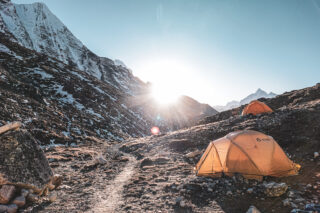
As we approach the base camp, the wide open space begins to narrow as the elevated banks of the Imja Lake create a corridor with the southeastern slopes of Island Peak. Once we arrive at the Base Camp, we’ll check in, have lunch, and head out for the second part of our training. The focus will be on the efficient use of the fixed ropes and proper crampon techniques. We’ll have an early dinner in order to try and get a good night’s rest before our summit push. The climbing guides will determine whether the summit push will be the following day based on weather conditions, route conditions, any additional training requirements, and the energy levels of the team. This decision is made with safety, timing, and summit viability in mind.
DAY 14: ISLAND PEAK SUMMIT DAY AT 6189 METERS
Distance: 12.7 KM | Ascent: 1,035 | Descent: 1,429 | Max Altitude: 6,189 M
If we choose to rest at the base camp for an additional day, then we’ll have a late breakfast, do some pre-lunch training, get as much rest as we can, and try to sleep early for the summit push. If we do head for the summit on this day, then we’ll get an early start, departing from the base camp at midnight.
Summit day is led by the climbing guides, who manage timing, rope movement, glacier travel, spacing, and descent decisions throughout the climb.
The trail starts along a dry trail that slowly climbs along the southeastern slopes of Island Peak. As the trail gets steeper, it will turn into a series of switchbacks before reaching a rocky spur that requires some very limited scrambling. The switchbacks continue until we reach a plateau known as crampon point, which we’ll likely reach at or around sunrise.
We’ll put on our technical gear here and take a short break before connecting ourselves to the fixed ropes and starting our ascent of the glacier. The start of the glacier is very beautiful, with towering wave-like walls of ice creating a maze of walkways, abseils, bridges, and plateaus that give this climb its incredible character.
Once we’ve successfully navigated this section, we’ll find ourselves on a flat and open plateau of snow and ice. The summit stands just above it and is clearly visible to us. The face climb to the top looks short from afar but is impressive, challenging, and takes at least one hour to complete.
After we traverse the plateau, we will connect to a series of three fixed ropes that go directly up the face. The incline can reach an impressive 40 degrees. Slow, steady progress without stopping is the key to success in this section. The third fixed rope tops out on the summit ridge. From there, it is usually about a ten-minute climb to the top.
The ridge is wide enough but can feel overwhelming because of the void on either side. It is important to concentrate on how we place our feet, use the ice axe efficiently, and rely on the fixed rope only as an added measure of security, secondary to employing our own skills and abilities.
At the top of the rope is the summit of Island Peak. True to its name, it sits like an island between the giants of the world. From the top, we have direct views of the Lhotse summit, Makalu in the distance, and Ama Dablam as if it’s a stone’s throw away. Depending on conditions, we may be able to take considerable time here to enjoy the views. However, as with all Himalayan summits, it’s important not to get too complacent. We aren’t done until we’re back at base camp.
We’ll begin our descent along the ridge. Once we reach the steep face, we will switch to abseiling on the ropes as we would have trained for over the previous days. Once we reach the snow plateau and have gained some distance from anything that may potentially fall from above, we’ll take a longer break.
From here, we’ll once again follow the trail to crampon point and descend along the dry trail to Base Camp where lunch will be waiting. In the early afternoon, we will depart in the direction of Chukung where we’ll have dinner and spend the night.
DAY 15: ISLAND PEAK RESERVE SUMMIT DAY OR RECOVERY DAY
In the event that climbing is not possible on the previous day due to weather or other conditions, we have set aside today as an alternative summit day. If we did manage to climb on the day before, then this will be a recovery day to relax in Dingboche, just below Chukung. Regardless of what happens on the previous day, this night will be spent in either Dingboche or Chukung.
If the reserve day is used for the summit, the same climbing guide led decision making applies. If the summit has already been completed, the day becomes a recovery and repositioning day based on weather, energy levels, and the final descent plan.
DAY 16: DESCEND FROM CHUKUNG OR DINGBOCHE TO TENGBOCHE
Distane 15.2 KM | Ascent: 296 M | Descent: 1,171 M | Max Altitude: 4,730 M
If we spent the previous night in Chukung, then we’ll begin our descent from there after breakfast. The trail follows a series of streams on an easy declining slope in the direction of Dingboche. This trail usually takes less than an hour to complete.
For those who have selected the optional high altitude helicopter return, this may be the point where your shortened descent begins, depending on the confirmed landing point, weather, and operational conditions. This is separate from the included Kathmandu to Lukla or Lukla to Kathmandu aviation sector. The high altitude helicopter return from the trail remains an optional paid add on.
For the rest of us, we’ll reconnect with the trail that follows the Khumbu River in the direction of Ama Dablam. As the valley starts to get steeper, the trail will veer to the right and follow an embankment that reconnects with the ascending trail that goes up to Pheriche in the direction of Everest Base Camp.
We’ll continue along the descending route until we reach the familiar town of Pangboche, where we’ll stop for lunch and take our time to enjoy the views of the border regions between the lush lower valley and the dazzling white peaks of the upper regions. We’ll resume the descent along the stairs that lead to the suspension bridge on the edge of the Rhododendron forest.
The challenging portion of the trail is actually the final ascent in the forest to the pass, where the Tyangboche monastery sits. Depending on the pace of the team, it may be possible to descend beyond the monastery to tea houses closer to Namche Bazaar. Our trekking team will assess the conditions closer to the time and brief the group on the final destination.
DAY 17: TREK FROM TENGBOCHE TO NAMCHE BAZAAR AND MONJO
Distance: 14.5 KM | Ascent: 688 M | Descent: 1,685 M | Max Altitude: 3,860 M
Tyangboche is the last truly remote village along the trail, and nothing represents this more acutely than departing from the monastery and passing through Namche Bazaar. Both are charming and beautiful in their own rights, but they couldn’t be more different.
The trail starts with a long descent to the valley floor before crossing a series of suspension bridges and ascending the pine forest to the junction between the Khumbu and Gokyo valleys. In the forest, we’ll stop at a tea house for a break before continuing to the high point of the day. This is the final big ascent of the entire experience.
As the trail returns toward Namche and Monjo, the expedition begins to feel human again. Market stalls, tea houses, caravans, and village life return after the wild remoteness of the upper Khumbu.
Depending on our pace, it may be possible to roam around before we continue our descent through the forest, across the Tenzing-Hillary suspension bridge, and finally to the valley floor where the town of Monjo awaits. Our night will be spent at a Tea House in the town.
DAY 18: TREK FROM MONJO TO LUKLA
Distance: 12.6 KM | Ascent: 722 M | Descent: 715 M | Max Altitude: 2,835 M
The end of the trail is the Sherpa village of Lukla, home to the Tenzing-Hillary airport. Monjo is within a few hours of Lukla. This gives us the option of catching a flight out on this day instead of the next, should we find that weather may obstruct flights on the following day.
Assuming that the conditions are favorable, we’ll start slowly after breakfast and take our time to visit and enjoy the many villages that are along this section of the trail. Yes, we did pass through them on the way up, but the mindset was different. It’s so much more enjoyable to have this experience once the objective of the adventure is behind us.
Lunch will be in Phakding along the trail, and we’ll have plenty of opportunities to stop for tea and coffee. The final push to Lukla is a mild challenge as we ascend a series of stairs and village trails to the entrance of the town. The afternoon is free to explore the coffee shops, pubs, markets, and stores. We’ll spend our last night on the trail at a local Tea House, where we’ll also share our last trail dinner.
Because the expedition includes one helicopter sector between Kathmandu and Lukla, the final aviation plan will depend on how the inbound journey was operated and what the weather allows. If the helicopter sector has not yet been used, it may be used from Lukla to Kathmandu to reduce the risk of delay. If it was used on the way in, the return from Lukla is usually by fixed wing flight, subject to weather and airport operations.
DAY 19: RETURN FROM LUKLA TO KATHMANDU
Hot showers await us on our return to Kathmandu. Depending on how the journey into Lukla was operated, today may involve either the included helicopter sector from Lukla to Kathmandu or the fixed wing flight back toward Kathmandu. The decision is made according to weather, airport operations, and the best available plan for the group. Patience is still part of Himalayan travel, but including one helicopter sector gives us more flexibility around one of the most unpredictable parts of the Island Peak Expedition.
Depending on when we move, lunch will either be in Lukla, Kathmandu, or the alternative airport sometimes used to direct Lukla air traffic that is inbound to Kathmandu. Wherever we finally land, we’ll do our best to get you to the hotel as soon as possible so that you can shower, rest, and enjoy Kathmandu before our farewell dinner.
DAY 20: DEPARTURE FROM KATHMANDU AFTER THE ISLAND PEAK EXPEDITION
The last day together is dedicated to airport transfer and farewells. Breakfast is included on the day. Please make sure to provide us with the correct departure details when filling out your Team Details Form before the first day of the trip so that arrangements can be made.
We’ll be arranging your shuttle 3 hours before departure, so please make sure to be near the hotel at the time so as not to be late. For those of us departing late, we’re happy to recommend places to visit or arrange for a city tour if you weren’t able to attend it on the first day.
Your LHO Team Leader will be available in Kathmandu to support departure arrangements. Please communicate any changes to your flight details as soon as possible so the final transfer plans can be updated smoothly.
CAN’T TAKE THIS MANY DAYS OFF?
It is possible to shorten this trip by adding an optional high altitude helicopter return from the trail after the Island Peak climb, usually from Dingboche or another suitable landing point depending on the final itinerary, weather, and operational conditions. This is separate from the included Kathmandu to Lukla or Lukla to Kathmandu aviation sector. Ask us about the shorter itinerary by reaching out to info@lifehappensoutdoors.com.


OUR COMMITMENT
We are dedicated to ensuring that everyone involved in our services receives a fair living wage in their respective countries. We invest in our team members, fostering upward mobility within the adventure travel industry, expanding educational opportunities, and offering support wherever we can. By joining an LHO adventure you are directly impacting the incredible people and the remote communities that make these life-changing experiences possible.
LEARN MOREHEALTH & SAFETY GUIDELINES
We do our best to ensure your wellbeing on LHO adventures. That's why the facilities we use throughout our trips are required to meet our health and safety standards. We also follow the laws and protocols of every country that hosts our adventures. This extends to national regulations requiring Covid-19 testing, vaccination certificates, mask wearing or any other local guidelines that may apply. Contact us for the most up to date protocols related to your destination.
LEARN MOREWill my Island Peak Expedition be led by an LHO Team Leader?
Yes. Your expedition is shaped by an LHO Team Leader, who will be present and available for Kathmandu based events, including arrival, the welcome briefing, team dinners, and departure support. Their role is to set the tone of the experience, support the group, and help create the seamless logistics, rhythm, and attentive care Life Happens Outdoors is known for. On the trail, you are guided by our expert Khumbu trekking team, while the Island Peak climb itself is led by certified high altitude climbing guides. Their knowledge of the route, altitude, glacier travel, fixed ropes, summit timing, and mountain conditions is central to the expedition.
Who leads the Island Peak summit climb?
The Island Peak summit climb is led by certified high altitude climbing guides. Your climbing guides manage the technical training, equipment checks, glacier travel, fixed ropes, summit timing, spacing, safety decisions, and descent. This is one of the most important parts of the expedition because Island Peak is not just a trek. It is a real Himalayan climb above 6,000 meters with technical mountain terrain.
Is a helicopter transfer included on the Island Peak Expedition?
Yes. Our Island Peak Expedition includes one helicopter sector between Kathmandu and Lukla, used either on the way into the mountains or on the way back from Lukla depending on weather, flight operations, and the best plan for the group. The other airport sector is usually completed by fixed wing domestic flight. This gives us more flexibility around Lukla, where delays are common.
This included helicopter sector applies only to Kathmandu to Lukla or Lukla to Kathmandu. Any helicopter return from higher on the trail, including after the Island Peak climb, remains a separate optional add on, subject to weather, landing conditions, aircraft availability, and the confirmed itinerary.
Is the high altitude helicopter return included?
No. The high altitude helicopter return from the trail is not included in the standard Island Peak Expedition price. It is an optional paid add on for those who want to shorten the descent after the climb, usually from Dingboche or another suitable landing point depending on conditions. This is separate from the included Kathmandu to Lukla or Lukla to Kathmandu aviation sector.
Where is Island Peak?
Island Peak—also known as Imja Tse—is located in the Everest region of Nepal, nestled between the north face of Ama Dablam, the south face of Lhotse, and just west of Makalu. It lies along a high-altitude valley off the main Everest trail and is typically reached as part of an Island Peak climb with Everest Base Camp trek. The mountain is about a three-day trek from Everest Base Camp, making it a natural extension for trekkers looking to add a true mountaineering experience to their journey.
Why is it called Island Peak?
Although the mountain’s official name is Imja Tse, it was nicknamed Island Peak by early British climbers because it appears like an island rising from a sea of ice when viewed from Dingboche. The name stuck, and today, climb Island Peak Nepal is one of the most popular introductory mountaineering objectives in the Everest region. Despite its “entry-level” label, the Island Peak climb offers a real taste of Himalayan expedition life, complete with glaciers, ladders, and fixed lines.
When is the best time to climb Island Peak?
The best seasons for an Island Peak climb are spring (March to May) and autumn (late September to November). During these periods, weather conditions are more stable, skies are generally clear, and temperatures are manageable—making it ideal for a safe and successful Island Peak climb expedition.
Spring offers blooming rhododendrons and warmer conditions, while autumn delivers crisp air and excellent visibility, especially from the summit. These windows also align well for those combining the Island Peak climb with Everest Base Camp trek, ensuring the full experience of both the trail and the peak.
How hard is Island Peak?
The Island Peak climb is considered a challenging but achievable Himalayan ascent, often described as an ideal introduction to mountaineering. While it’s labeled a “trekking peak,” the climb involves real technical elements—such as steep snow slopes, glacier travel, ladder crossings, and a final headwall ascent using fixed ropes.
Good physical fitness, prior high-altitude trekking experience, and basic mountaineering training are highly recommended. Many climbers choose to climb Island Peak Nepal as a natural next step after completing the Everest Base Camp trek, giving them time to acclimatise before attempting the 6,189-meter summit.
How fit do I need to be to climb Island Peak?
The Island Peak climb is ranked as Enduring by LHO, meaning it requires consistent physical preparation and mental resilience. While you don’t need to be a professional athlete to climb Island Peak Nepal, regular training is essential to safely enjoy and succeed on this high-altitude Island Peak climb expedition.
You should dedicate 3 to 4 days a week to focused training in the lead-up to your trip. Here’s what to include:
Cardio: Running, hiking, uphill walking, cycling, stair climbing, or swimming to build aerobic endurance.
Strength: Push-ups, squats, lunges, planks—focus on legs and core.
Flexibility: Yoga or stretching to improve mobility and prevent injuries.
HIIT: High-Intensity Interval Training for stamina and agility.
Mental Resilience: Ice baths, meditation, isometric holds, and stress management to build the mental toughness needed for summit day.
Combining this physical and mental preparation ensures you’re ready for the demands of the Island Peak climb route, including glacier travel, altitude, and summit push.
How high is Island Peak?
Island Peak, officially known as Imja Tse, stands at 6,189 meters (20,305 feet) above sea level.
Can I climb Island Peak if I have never been mountaineering before?
Yes, Island Peak can be suitable for first time mountaineers with strong fitness, good preparation, and the right mindset. It is often described as an introductory Himalayan climbing peak, but that does not mean it is easy. The climb involves altitude, glacier travel, crampons, fixed ropes, abseiling, and a summit above 6,000 meters. We include technical training during the expedition, and the summit phase is led by certified high altitude climbing guides.
What is the accommodation like on the Island Peak Expedition?
During the Island Peak Expedition, accommodation varies between Kathmandu hotels, mountain tea houses, and technical tents at Island Peak Base Camp. In Kathmandu, we use carefully selected hotels that blend comfort, location, and local character, with easy access to markets, restaurants, and walking areas.
On the trail, we stay in tea houses, which are locally run mountain lodges and a central part of trekking in the Himalayas. Tea houses become simpler as we move higher into the Khumbu, but we select the best available standard where possible. In Phakding and Namche, where the accommodation options are stronger, we use higher quality tea houses to give you better comfort, atmosphere, and recovery early in the journey.
For the Island Peak climb itself, we transition to technical mountaineering tents at Base Camp. This is a more basic expedition environment, but it puts us in the right place for training, rest, and the summit push.
How can I charge my devices and power banks? Do tea houses charge for using electrical outlets?
Yes, it’s possible to charge your devices during the Island Peak climb expedition, especially while staying in tea houses along the Everest Base Camp trek route. However, electrical outlets are limited and in high demand—so it’s wise to charge your power banks whenever the opportunity arises.
Most tea houses charge a small fee—typically between 200 to 500 Nepali Rupees ($2 to $5 USD)—to charge devices or power banks. We recommend bringing at least one or two fully charged power banks to stay topped up, especially during the Island Peak climb, where charging facilities are unavailable at Base Camp.
At the base camp charging is not possible. Our last opportunity to charge will be at the last tea house. Consider having enough power bank capacity for three days without recharging.
How much should I carry as spending cash?
For the Island Peak climb expedition, we recommend carrying around $200 USD for personal expenses such as snacks, charging fees, and souvenirs along the trek. This amount does not include any tips.
Our suggested tipping amount for the guides, porters, and team members is $350 USD, which can be shared between the crew who support you throughout the Island Peak climb experience.
PAYMENT PLANS AVAILABLE
FROM $9,572
$8,806
on selected dates only
DOWNLOAD YOUR TRIP GUIDEBOOK


INQUIRE NOW
This adventure is only available as a private trip and is customized to your requirements, experience and skill level. To get started, please fill out the form below. We’ll be in touch soon to put it together for you.
"(Required)" indicates required fields
CONTACT US
We’re passionate about guiding you to epic adventures and beyond. If you have any questions at all, don’t hesitate to reach out. We’d love to hear from you.
JOIN THE LIFE HAPPENS OUTDOORS COMMUNITY!
Get £100 off your next adventure!
Sign Up To The Newsletter